Surbo night lights from space
Night Light of Surbo (Apulia) from space (Italy) Src. Average luminocity for 10x10km area is 58.8963% and for 50x50km: 22.5257%.
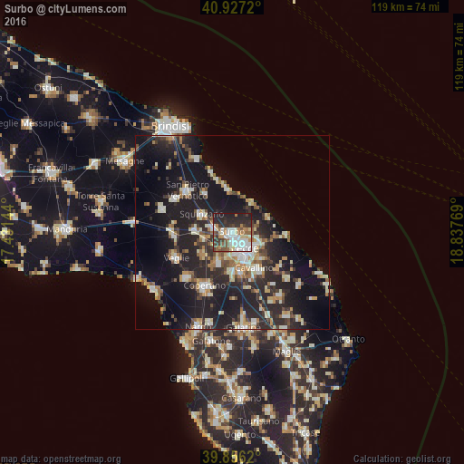
Analysis of Surbo night lights 2016
Square area 10x10 km:
 14.29%
90-99
15.14%80-89
4.76%70-79
6.63%60-69
5.44%50-59
8.33%40-49
7.14%30-39
9.86%20-29
21.26%10-19
7.14%0-9
0%Square area 50x50 km:
2.62%90-99
4.18%80-89
2.51%70-79
2.25%60-69
2.67%50-59
2.48%40-49
2.57%30-39
3.63%20-29
10.06%10-19
22.09%0-9
44.93%Clear (daylight) street map image can be seen on geolist.org.
Map coordinates:
40° 55' 37.9" North, 17° 25' 53.2" East
40° 23' 37.8" North, 18° 8' 4.4" East
39° 51' 22.3" North, 18° 50' 15.7" East
Some cities around Surbo sort by population:
• Lecce
5.4 km =3.4 mi,  143°
143°
• Squinzano
9.2 km =5.7 mi,  300°
300°
• Trepuzzi
5.1 km =3.2 mi,  284°
284°
• Monteroni di Lecce
9.1 km =5.7 mi,  203°
203°
• Campi Salentina
9.6 km =6 mi,  272°
272°
• Carmiano
9.6 km =6 mi,  234°
234°
• Lequile
9.8 km =6.1 mi,  177°
177°
• Novoli
7.6 km =4.7 mi,  255°
255°
3166021 (p: 11,363)
Sources (retrieved 2019-11-25):
» Earth at Night: Flat Maps 2012, 2016