Campi Salentina night lights from space
Night Light of Campi Salentina (Apulia) from space (Italy) Src. Average luminocity for 10x10km area is 40.7177% and for 50x50km: 23.7049%.
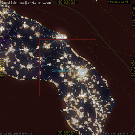
Analysis of Campi Salentina night lights 2016
Square area 10x10 km:
 3.74%
3.74%90-99
7.82%80-89
4.76%70-79
2.55%60-69
7.65%50-59
3.4%40-49
4.76%30-39
11.9%20-29
24.49%10-19
28.91%0-9
0%Square area 50x50 km:
2.74%90-99
4.21%80-89
2.73%70-79
2.48%60-69
3%50-59
2.72%40-49
2.72%30-39
3.72%20-29
10.1%10-19
22.38%0-9
43.19%Clear (daylight) street map image can be seen on geolist.org.
Map coordinates:
40° 55' 51" North, 17° 19' 5.8" East
40° 23' 50.9" North, 18° 1' 17.1" East
39° 51' 35.5" North, 18° 43' 28.3" East
Some cities around Campi Salentina sort by population:
• Squinzano
4.5 km =2.8 mi,  21°
21°
• Trepuzzi
4.7 km =2.9 mi,  79°
79°
• Veglie
8.6 km =5.3 mi,  215°
215°
• Surbo
9.6 km =6 mi,  92°
92°
• Carmiano
6.2 km =3.9 mi,  163°
163°
• Salice Salentino
5.3 km =3.3 mi,  254°
254°
• Novoli
3.2 km =2 mi,  136°
136°
• Cellino San Marco
9.5 km =5.9 mi,  329°
329°
3181005 (p: 10,596)
Sources (retrieved 2019-11-25):
» Earth at Night: Flat Maps 2012, 2016