Santhià night lights from space
Night Light of Santhià (Piedmont) from space (Italy) Src. Average luminocity for 10x10km area is 15.3984% and for 50x50km: 17.4185%.
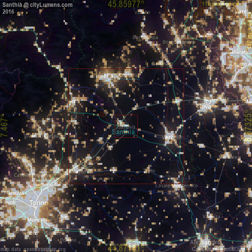
Analysis of Santhià night lights 2016
Square area 10x10 km:
 1.9%
1.9%90-99
3.02%80-89
0.79%70-79
1.43%60-69
3.02%50-59
1.27%40-49
1.11%30-39
2.06%20-29
2.22%10-19
11.11%0-9
72.06%Square area 50x50 km:
1.71%90-99
2.55%80-89
1.49%70-79
2.14%60-69
2.26%50-59
2.83%40-49
2.41%30-39
2.32%20-29
5.12%10-19
15.25%0-9
61.92%Clear (daylight) street map image can be seen on geolist.org.
Map coordinates:
45° 51' 35.2" North, 7° 28' 1.2" East
45° 22' 4.6" North, 8° 10' 12.4" East
44° 52' 18.5" North, 8° 52' 23.7" East
Some cities around Santhià sort by population:
• Vercelli
20.2 km =12.6 mi,  104°
104°
• Biella
23.4 km =14.5 mi,  338°
338°
• Cossato
22.5 km =14 mi,  2°
2°
• Vigliano Biellese
22.3 km =13.9 mi,  346°
346°
• Candelo
19.9 km =12.4 mi, 345°
• Trino
21.6 km =13.4 mi,  152°
152°
• Crescentino
19.9 km =12.4 mi,  199°
199°
• Caluso
22.9 km =14.2 mi,  252°
252°
3167314 (p: 8,079)
Sources (retrieved 2019-11-25):
» Earth at Night: Flat Maps 2012, 2016