San Giuseppe Jato night lights from space
Night Light of San Giuseppe Jato (Sicily) from space (Italy) Src. Average luminocity for 10x10km area is 10.5536% and for 50x50km: 17.5147%.
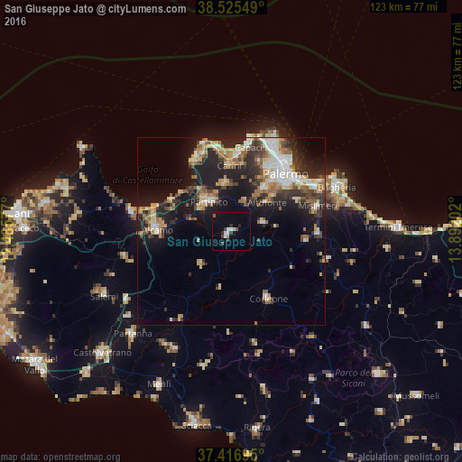
Analysis of San Giuseppe Jato night lights 2016
Square area 10x10 km:
 1.79%
1.79%90-99
1.46%80-89
0%70-79
1.3%60-69
0.32%50-59
1.62%40-49
0.49%30-39
2.11%20-29
1.95%10-19
2.76%0-9
86.2%Square area 50x50 km:
2.7%90-99
2.4%80-89
2.19%70-79
2.3%60-69
2.37%50-59
2.39%40-49
2.13%30-39
3.17%20-29
5.76%10-19
11.71%0-9
62.87%Clear (daylight) street map image can be seen on geolist.org.
Map coordinates:
38° 31' 31.8" North, 12° 29' 8.8" East
37° 58' 23.9" North, 13° 11' 20" East
37° 25' 1" North, 13° 53' 31.3" East
Some cities around San Giuseppe Jato sort by population:
• Carini
17.7 km =11 mi,  358°
358°
• Partinico
10.3 km =6.4 mi,  322°
322°
• Monreale
14.9 km =9.3 mi,  36°
36°
• Altofonte
12.1 km =7.5 mi,  50°
50°
• Borgetto
9.2 km =5.7 mi,  332°
332°
• Balestrate
18.1 km =11.2 mi,  298°
298°
• Piana degli Albanesi
8.7 km =5.4 mi,  74°
74°
• San Cipirello
1.7 km =1.1 mi,  215°
215°
2523451 (p: 8,245)
Sources (retrieved 2019-11-25):
» Earth at Night: Flat Maps 2012, 2016