Salò night lights from space
Night Light of Salò (Lombardy) from space (Italy) Src. Average luminocity for 10x10km area is 42.6076% and for 50x50km: 28.508%.
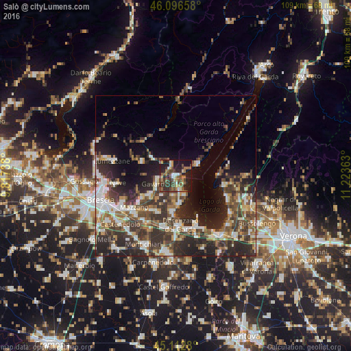
Analysis of Salò night lights 2016
Square area 10x10 km:
 4.09%
4.09%90-99
4.09%80-89
4.39%70-79
3.79%60-69
9.85%50-59
9.24%40-49
11.82%30-39
11.36%20-29
15.91%10-19
24.09%0-9
1.36%Square area 50x50 km:
4.14%90-99
5.12%80-89
2.3%70-79
2.93%60-69
3.76%50-59
4.63%40-49
6.36%30-39
7.22%20-29
11.24%10-19
10.31%0-9
42.01%Clear (daylight) street map image can be seen on geolist.org.
Map coordinates:
46° 5' 47.7" North, 9° 49' 2.6" East
45° 36' 24.7" North, 10° 31' 13.8" East
45° 6' 46.1" North, 11° 13' 25.1" East
Some cities around Salò sort by population:
• Bedizzole
13.1 km =8.1 mi,  215°
215°
• Piazza
13.2 km =8.2 mi,  214°
214°
• Gavardo-Sopraponte
6.4 km =4 mi,  252°
252°
• Toscolano Maderno
7.7 km =4.8 mi,  61°
61°
• Sirmione
13.8 km =8.6 mi,  151°
151°
• Prevalle
9.8 km =6.1 mi,  231°
231°
• Vobarno
4.2 km =2.6 mi,  336°
336°
• Villanuova sul Clisi
5.3 km =3.3 mi,  261°
261°
3168633 (p: 8,165)
Sources (retrieved 2019-11-25):
» Earth at Night: Flat Maps 2012, 2016