Ramacca night lights from space
Night Light of Ramacca (Sicily) from space (Italy) Src. Average luminocity for 10x10km area is 8.0016% and for 50x50km: 8.9811%.
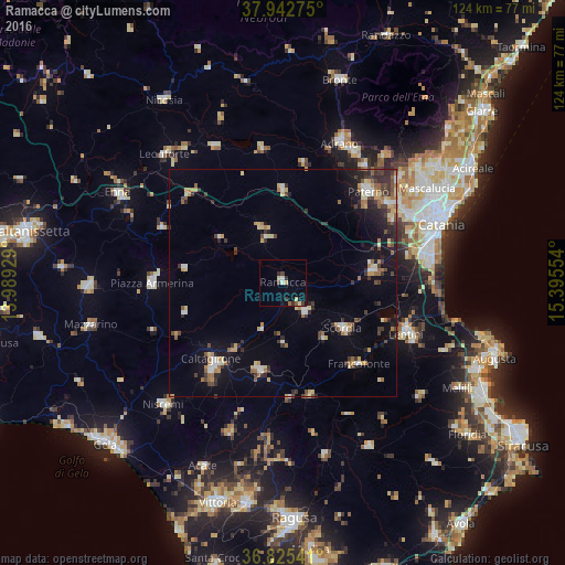
Analysis of Ramacca night lights 2016
Square area 10x10 km:
 0.65%
0.65%90-99
1.14%80-89
1.46%70-79
0.65%60-69
0.65%50-59
0.65%40-49
1.46%30-39
1.3%20-29
1.79%10-19
1.46%0-9
88.8%Square area 50x50 km:
0.8%90-99
0.88%80-89
1.21%70-79
1.08%60-69
1.24%50-59
1.05%40-49
1.16%30-39
2.02%20-29
2.1%10-19
4.44%0-9
84.03%Clear (daylight) street map image can be seen on geolist.org.
Map coordinates:
37° 56' 33.9" North, 13° 59' 21.4" East
37° 23' 10.2" North, 14° 41' 32.7" East
36° 49' 31.5" North, 15° 23' 43.9" East
Some cities around Ramacca sort by population:
• Caltagirone
22.7 km =14.1 mi,  223°
223°
• Scordia
16.5 km =10.3 mi,  127°
127°
• Palagonia
7.8 km =4.8 mi,  143°
143°
• Grammichele
19.9 km =12.4 mi,  195°
195°
• Francofonte
24.1 km =15 mi, 138°
• Militello in Val di Catania
15.2 km =9.4 mi, 143°
• Vizzini
25.6 km =15.9 mi,  167°
167°
• Mirabella Imbaccari
22.7 km =14.1 mi,  253°
253°
2523644 (p: 10,137)
Sources (retrieved 2019-11-25):
» Earth at Night: Flat Maps 2012, 2016