Popoli night lights from space
Night Light of Popoli (Abruzzo) from space (Italy) Src. Average luminocity for 10x10km area is 14.3788% and for 50x50km: 11.6032%.
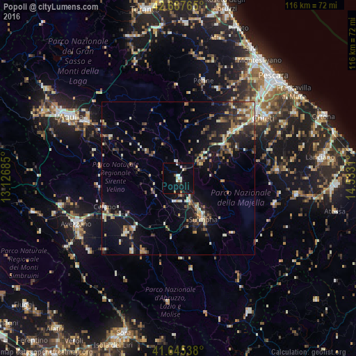
Analysis of Popoli night lights 2016
Square area 10x10 km:
 1.52%
1.52%90-99
3.18%80-89
0.76%70-79
1.21%60-69
1.21%50-59
0.45%40-49
1.06%30-39
1.36%20-29
1.52%10-19
18.18%0-9
69.55%Square area 50x50 km:
0.51%90-99
2.18%80-89
1.16%70-79
1.51%60-69
1.48%50-59
1.67%40-49
1.5%30-39
2.09%20-29
3.56%10-19
9.09%0-9
75.24%Clear (daylight) street map image can be seen on geolist.org.
Map coordinates:
42° 41' 15.5" North, 13° 7' 36.7" East
42° 10' 7.2" North, 13° 49' 47.9" East
41° 38' 43.4" North, 14° 31' 59.2" East
Some cities around Popoli sort by population:
• Chieti
34 km =21.1 mi,  54°
54°
• Avezzano
36.7 km =22.8 mi,  244°
244°
• Sulmona
15.4 km =9.6 mi,  149°
149°
• Celano
27.6 km =17.1 mi,  249°
249°
• Pratola Peligna
8.8 km =5.5 mi,  155°
155°
• Trasacco
34 km =21.1 mi,  226°
226°
• Penne
32.8 km =20.4 mi,  14°
14°
• Luco dei Marsi
37.5 km =23.3 mi, 231°
3170175 (p: 5,394)
Sources (retrieved 2019-11-25):
» Earth at Night: Flat Maps 2012, 2016