Pellaro night lights from space
Night Light of Pellaro (Calabria) from space (Italy) Src. Average luminocity for 10x10km area is 23.8019% and for 50x50km: 13.6498%.
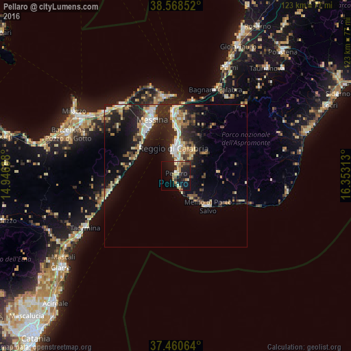
Analysis of Pellaro night lights 2016
Square area 10x10 km:
 0.65%
0.65%90-99
1.14%80-89
3.9%70-79
6.17%60-69
4.22%50-59
2.11%40-49
2.11%30-39
3.25%20-29
10.71%10-19
29.06%0-9
36.69%Square area 50x50 km:
1.35%90-99
2%80-89
2.19%70-79
1.88%60-69
1.86%50-59
1.21%40-49
1.34%30-39
2.19%20-29
5.78%10-19
9.94%0-9
70.26%Clear (daylight) street map image can be seen on geolist.org.
Map coordinates:
38° 34' 6.7" North, 14° 56' 48.8" East
38° 1' 0" North, 15° 39' 0" East
37° 27' 38.3" North, 16° 21' 11.3" East
Some cities around Pellaro sort by population:
• Messina
21.5 km =13.4 mi,  336°
336°
• Reggio Calabria
10.5 km =6.5 mi,  5°
5°
• Villa San Giovanni
22.6 km =14 mi,  357°
357°
• Melito di Porto Salvo
13.3 km =8.3 mi,  138°
138°
• Bagnara Calabra
33.1 km =20.6 mi,  24°
24°
• Villafranca Tirrena
30.9 km =19.2 mi,  323°
323°
• Santa Teresa di Riva
26 km =16.2 mi,  252°
252°
• Torregrotta
33.4 km =20.8 mi,  308°
308°
2523845 (p: 13,000)
Sources (retrieved 2019-11-25):
» Earth at Night: Flat Maps 2012, 2016