Melito di Porto Salvo night lights from space
Night Light of Melito di Porto Salvo (Calabria) from space (Italy) Src. Average luminocity for 10x10km area is 16.1526% and for 50x50km: 6.5745%.
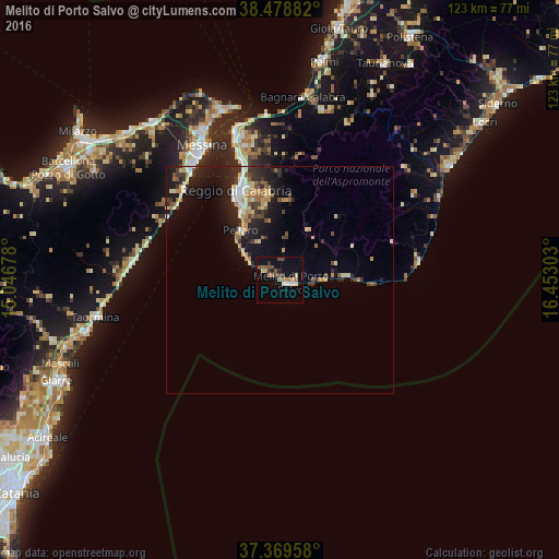
Analysis of Melito di Porto Salvo night lights 2016
Square area 10x10 km:
 0.49%
0.49%90-99
1.95%80-89
2.6%70-79
1.46%60-69
3.08%50-59
4.38%40-49
1.79%30-39
2.76%20-29
0.97%10-19
3.57%0-9
76.95%Square area 50x50 km:
0.5%90-99
0.85%80-89
1.08%70-79
0.93%60-69
0.9%50-59
0.75%40-49
0.76%30-39
1.01%20-29
2.22%10-19
5.18%0-9
85.82%Clear (daylight) street map image can be seen on geolist.org.
Map coordinates:
38° 28' 43.8" North, 15° 2' 48.4" East
37° 55' 34.6" North, 15° 44' 59.6" East
37° 22' 10.5" North, 16° 27' 10.9" East
Some cities around Melito di Porto Salvo sort by population:
• Messina
34.4 km =21.4 mi,  329°
329°
• Reggio Calabria
21.9 km =13.6 mi,  339°
339°
• Villa San Giovanni
34.1 km =21.2 mi, 343°
• Pellaro
13.3 km =8.3 mi,  318°
318°
• Bagnara Calabra
40.5 km =25.2 mi,  6°
6°
• Santa Teresa di Riva
33.7 km =20.9 mi,  273°
273°
• Giardini-Naxos
43.8 km =27.2 mi,  255°
255°
• Taormina
41.3 km =25.7 mi, 258°
2524181 (p: 9,663)
Sources (retrieved 2019-11-25):
» Earth at Night: Flat Maps 2012, 2016