Offanengo night lights from space
Night Light of Offanengo (Lombardy) from space (Italy) Src. Average luminocity for 10x10km area is 41.7317% and for 50x50km: 37.7293%.
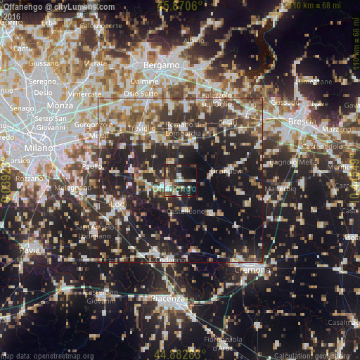
Analysis of Offanengo night lights 2016
Square area 10x10 km:
 6.03%
6.03%90-99
10.16%80-89
3.02%70-79
3.49%60-69
4.6%50-59
5.4%40-49
6.98%30-39
7.46%20-29
20.63%10-19
26.98%0-9
5.24%Square area 50x50 km:
5.3%90-99
7.02%80-89
3.5%70-79
4.04%60-69
5.32%50-59
5.81%40-49
5.48%30-39
6.78%20-29
16.62%10-19
22.48%0-9
17.64%Clear (daylight) street map image can be seen on geolist.org.
Map coordinates:
45° 52' 14.2" North, 9° 2' 21.2" East
45° 22' 43.9" North, 9° 44' 32.5" East
44° 52' 58.2" North, 10° 26' 43.8" East
Some cities around Offanengo sort by population:
• Crema
5.1 km =3.2 mi,  249°
249°
• Romano di Lombardia
15.8 km =9.8 mi,  3°
3°
• Caravaggio
15.2 km =9.4 mi,  328°
328°
• Orzinuovi
14.4 km =8.9 mi,  79°
79°
• Soresina
13.6 km =8.5 mi,  137°
137°
• Castelleone
9.4 km =5.8 mi,  171°
171°
• Pandino
15.1 km =9.4 mi,  281°
281°
• Soncino
10.1 km =6.3 mi, 76°
3172107 (p: 5,759)
Sources (retrieved 2019-11-25):
» Earth at Night: Flat Maps 2012, 2016