Gambettola night lights from space
Night Light of Gambettola (Emilia-Romagna) from space (Italy) Src. Average luminocity for 10x10km area is 51.8045% and for 50x50km: 24.7503%.
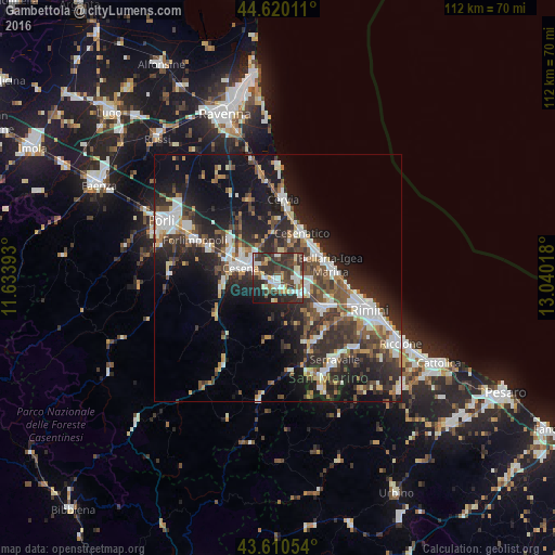
Analysis of Gambettola night lights 2016
Square area 10x10 km:
 8.18%
8.18%90-99
11.97%80-89
6.21%70-79
4.39%60-69
3.94%50-59
6.06%40-49
9.7%30-39
20.45%20-29
21.36%10-19
7.42%0-9
0.3%Square area 50x50 km:
4.09%90-99
4.81%80-89
1.73%70-79
2.03%60-69
2.69%50-59
3.51%40-49
4.73%30-39
5.07%20-29
10.13%10-19
14.62%0-9
46.58%Clear (daylight) street map image can be seen on geolist.org.
Map coordinates:
44° 37' 12.4" North, 11° 38' 2.1" East
44° 7' 2.9" North, 12° 20' 13.4" East
43° 36' 37.9" North, 13° 2' 24.6" East
Some cities around Gambettola sort by population:
• Cesena
7.9 km =4.9 mi,  287°
287°
• Cesenatico
10.4 km =6.5 mi,  28°
28°
• Bellaria-Igea Marina
11.1 km =6.9 mi,  75°
75°
• Savignano sul Rubicone
5.8 km =3.6 mi,  121°
121°
• Santarcangelo
10.6 km =6.6 mi, 124°
• San Mauro Pascoli
6.7 km =4.2 mi,  98°
98°
• Villa Verucchio
14.8 km =9.2 mi,  147°
147°
• Gatteo-Sant'Angelo
4.4 km =2.7 mi, 98°
3176334 (p: 10,034)
Sources (retrieved 2019-11-25):
» Earth at Night: Flat Maps 2012, 2016