Fiumefreddo Sicilia night lights from space
Night Light of Fiumefreddo Sicilia (Sicily) from space (Italy) Src. Average luminocity for 10x10km area is 43.0544% and for 50x50km: 16.2277%.
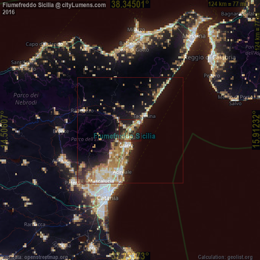
Analysis of Fiumefreddo Sicilia night lights 2016
Square area 10x10 km:
 3.06%
3.06%90-99
2.21%80-89
6.46%70-79
10.54%60-69
9.69%50-59
6.29%40-49
9.01%30-39
7.14%20-29
19.73%10-19
23.3%0-9
2.55%Square area 50x50 km:
1.85%90-99
2.46%80-89
2.87%70-79
2.71%60-69
3.33%50-59
1.65%40-49
1.65%30-39
1.84%20-29
3.87%10-19
9.26%0-9
68.52%Clear (daylight) street map image can be seen on geolist.org.
Map coordinates:
38° 20' 42" North, 14° 30' 21.9" East
37° 47' 29.3" North, 15° 12' 33.1" East
37° 14' 1.4" North, 15° 54' 44.4" East
Some cities around Fiumefreddo Sicilia sort by population:
• Acireale
20.7 km =12.9 mi,  190°
190°
• Giarre
7.8 km =4.8 mi,  197°
197°
• Riposto
6.6 km =4.1 mi,  182°
182°
• Mascali
3.9 km =2.4 mi, 196°
• Zafferana Etnea
15.5 km =9.6 mi,  216°
216°
• Giardini-Naxos
6.5 km =4 mi,  51°
51°
• Taormina
9.8 km =6.1 mi, 45°
• Linguaglossa
8.5 km =5.3 mi,  312°
312°
2524742 (p: 9,483)
Sources (retrieved 2019-11-25):
» Earth at Night: Flat Maps 2012, 2016