Cesa night lights from space
Night Light of Cesa (Campania) from space (Italy) Src. Average luminocity for 10x10km area is 95.1905% and for 50x50km: 49.7355%.
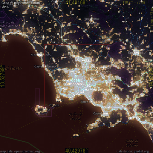
Analysis of Cesa night lights 2016
Square area 10x10 km:
 53.91%
90-99
28.06%80-89
7.31%70-79
8.33%60-69
2.38%50-59
0%40-49
0%30-39
0%20-29
0%10-19
0%0-9
0%Square area 50x50 km:
12.77%90-99
12.19%80-89
4.95%70-79
6.53%60-69
6.73%50-59
5.31%40-49
3.84%30-39
6.26%20-29
8.43%10-19
15.75%0-9
17.25%Clear (daylight) street map image can be seen on geolist.org.
Map coordinates:
41° 29' 30.1" North, 13° 31' 39.7" East
40° 57' 46.3" North, 14° 13' 50.9" East
40° 25' 47.2" North, 14° 56' 2.2" East
Some cities around Cesa sort by population:
• Aversa
2.2 km =1.4 mi,  298°
298°
• Sant'Antimo
2.3 km =1.4 mi,  171°
171°
• Orta di Atella
3.2 km =2 mi,  86°
86°
• Frattaminore
3.5 km =2.2 mi,  102°
102°
• Sant'Arpino
1.8 km =1.1 mi,  110°
110°
• Gricignano di Aversa
1.9 km =1.2 mi,  0°
0°
• Succivo
2.2 km =1.4 mi,  74°
74°
• Carinaro
2.4 km =1.5 mi,  337°
337°
3178984 (p: 8,496)
Sources (retrieved 2019-11-25):
» Earth at Night: Flat Maps 2012, 2016