Ca' Savio night lights from space
Night Light of Ca' Savio (Veneto) from space (Italy) Src. Average luminocity for 10x10km area is 22.3079% and for 50x50km: 23.3244%.
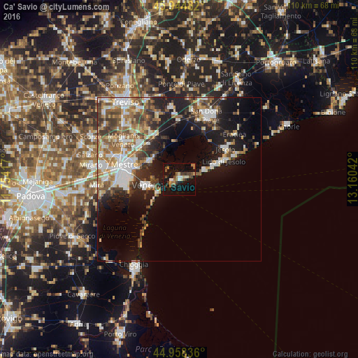
Analysis of Ca' Savio night lights 2016
Square area 10x10 km:
 1.59%
1.59%90-99
2.7%80-89
2.06%70-79
2.7%60-69
4.6%50-59
3.02%40-49
2.7%30-39
6.03%20-29
0.63%10-19
27.94%0-9
46.03%Square area 50x50 km:
4.33%90-99
4.6%80-89
2.06%70-79
2.45%60-69
3.51%50-59
3.76%40-49
3.26%30-39
3.88%20-29
4.53%10-19
12.83%0-9
54.78%Clear (daylight) street map image can be seen on geolist.org.
Map coordinates:
45° 56' 41.4" North, 11° 45' 15" East
45° 27' 13.5" North, 12° 27' 26.2" East
44° 57' 30.1" North, 13° 9' 37.5" East
Some cities around Ca' Savio sort by population:
• Mestre
17.1 km =10.6 mi,  284°
284°
• Venice
9.9 km =6.2 mi,  259°
259°
• Lido
8.6 km =5.3 mi,  235°
235°
• Marcon-Gaggio-Colmello
17.4 km =10.8 mi,  314°
314°
• Lido di Jesolo
15.9 km =9.9 mi,  68°
68°
• Iesolo
17.1 km =10.6 mi,  58°
58°
• Giudecca
10.5 km =6.5 mi,  252°
252°
• Quarto d'Altino
15.4 km =9.6 mi,  334°
334°
8224698 (p: 5,737)
Sources (retrieved 2019-11-25):
» Earth at Night: Flat Maps 2012, 2016