Breo night lights from space
Night Light of Breo (Piedmont) from space (Italy) Src. Average luminocity for 10x10km area is 33.4286% and for 50x50km: 11.49%.
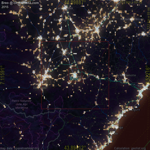
Analysis of Breo night lights 2016
Square area 10x10 km:
 4.76%
4.76%90-99
6.19%80-89
1.75%70-79
5.56%60-69
1.75%50-59
4.29%40-49
2.7%30-39
5.08%20-29
8.25%10-19
57.62%0-9
2.06%Square area 50x50 km:
0.94%90-99
1.7%80-89
0.93%70-79
1.19%60-69
1.08%50-59
1.56%40-49
1.84%30-39
2.16%20-29
2.37%10-19
12.46%0-9
73.77%Clear (daylight) street map image can be seen on geolist.org.
Map coordinates:
44° 53' 55.9" North, 7° 6' 57.3" East
44° 23' 55.1" North, 7° 49' 8.5" East
43° 53' 38.8" North, 8° 31' 19.8" East
Some cities around Breo sort by population:
• Cuneo
21.5 km =13.4 mi,  267°
267°
• Bra
33.4 km =20.8 mi,  4°
4°
• Mondovì
0.3 km =0.2 mi,  200°
200°
• Fossano
18.7 km =11.6 mi,  334°
334°
• Savigliano
30.6 km =19 mi,  335°
335°
• Borgo San Dalmazzo
26.8 km =16.7 mi,  255°
255°
• Boves
22.9 km =14.2 mi,  250°
250°
• Busca
30.2 km =18.8 mi,  295°
295°
8948728 (p: 14,772)
Sources (retrieved 2019-11-25):
» Earth at Night: Flat Maps 2012, 2016