Arienzo night lights from space
Night Light of Arienzo (Campania) from space (Italy) Src. Average luminocity for 10x10km area is 45.1531% and for 50x50km: 47.0921%.
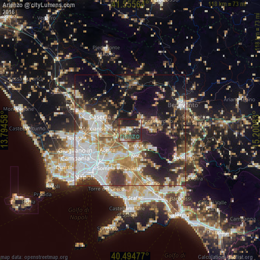
Analysis of Arienzo night lights 2016
Square area 10x10 km:
 3.06%
3.06%90-99
7.31%80-89
4.93%70-79
3.06%60-69
11.22%50-59
6.29%40-49
10.37%30-39
10.54%20-29
34.69%10-19
8.5%0-9
0%Square area 50x50 km:
10.8%90-99
10.19%80-89
4.59%70-79
5.52%60-69
7.46%50-59
5.66%40-49
5.01%30-39
7.55%20-29
10.49%10-19
16.85%0-9
15.88%Clear (daylight) street map image can be seen on geolist.org.
Map coordinates:
41° 33' 20.3" North, 13° 47' 40.5" East
41° 1' 38.4" North, 14° 29' 51.7" East
40° 29' 41.2" North, 15° 12' 3" East
Some cities around Arienzo sort by population:
• San Felice A Cancello
1.4 km =0.9 mi,  217°
217°
• Santa Maria A Vico
2.7 km =1.7 mi,  267°
267°
• Cicciano
7.7 km =4.8 mi,  156°
156°
• Sant'Agata de'Goti
6.9 km =4.3 mi,  359°
359°
• Airola
6.2 km =3.9 mi,  55°
55°
• Cimitile
9.7 km =6 mi,  166°
166°
• Roccarainola
7.2 km =4.5 mi,  148°
148°
• Camposano
8.8 km =5.5 mi, 162°
3182848 (p: 5,333)
Sources (retrieved 2019-11-25):
» Earth at Night: Flat Maps 2012, 2016