Agerola night lights from space
Night Light of Agerola (Campania) from space (Italy) Src. Average luminocity for 10x10km area is 23.1932% and for 50x50km: 27.0691%.
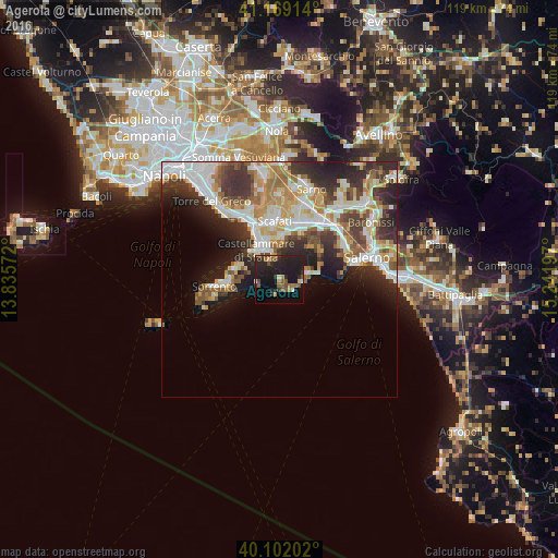
Analysis of Agerola night lights 2016
Square area 10x10 km:
 0%
0%90-99
1.95%80-89
2.11%70-79
0.49%60-69
5.19%50-59
4.55%40-49
5.19%30-39
2.92%20-29
15.42%10-19
34.58%0-9
27.6%Square area 50x50 km:
5.26%90-99
6.18%80-89
3.02%70-79
3.42%60-69
3.72%50-59
3.56%40-49
2.83%30-39
5.31%20-29
7.13%10-19
7.88%0-9
51.69%Clear (daylight) street map image can be seen on geolist.org.
Map coordinates:
41° 10' 8.9" North, 13° 50' 8.6" East
40° 38' 15.8" North, 14° 32' 19.8" East
40° 6' 7.3" North, 15° 14' 31.1" East
Some cities around Agerola sort by population:
• Castellammare di Stabia
8.4 km =5.2 mi,  328°
328°
• Gragnano
5.9 km =3.7 mi,  344°
344°
• Vico Equense
9.2 km =5.7 mi,  285°
285°
• Santa Maria La Carità
9.1 km =5.7 mi, 344°
• Pianillo
1 km =0.6 mi,  114°
114°
• Pimonte
4.7 km =2.9 mi, 328°
• Lettere
7.5 km =4.7 mi,  3°
3°
• Maiori
8.7 km =5.4 mi,  82°
82°
3183446 (p: 7,348)
Sources (retrieved 2019-11-25):
» Earth at Night: Flat Maps 2012, 2016