Turuvekere night lights from space
Night Light of Turuvekere (Karnataka) from space (India) Src. Average luminocity for 10x10km area is 9.7468% and for 50x50km: 5.1597%.
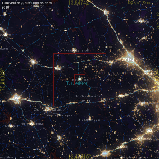
Analysis of Turuvekere night lights 2016
Square area 10x10 km:
 0.65%
0.65%90-99
2.16%80-89
0.65%70-79
0%60-69
0%50-59
1.73%40-49
3.46%30-39
4.98%20-29
2.81%10-19
0%0-9
83.55%Square area 50x50 km:
0.09%90-99
0.36%80-89
0.7%70-79
0.37%60-69
0.63%50-59
0.95%40-49
1.41%30-39
1.32%20-29
1.85%10-19
2.15%0-9
90.17%Clear (daylight) street map image can be seen on geolist.org.
Map coordinates:
13° 50' 50.7" North, 75° 57' 47.8" East
13° 9' 49.5" North, 76° 39' 59.1" East
12° 28' 41.3" North, 77° 22' 10.3" East
Some cities around Turuvekere sort by population:
• Tiptūr
22.9 km =14.2 mi,  296°
296°
• Channarāyapatna
41.6 km =25.8 mi,  226°
226°
• Kunigal
41.9 km =26 mi,  111°
111°
• Chiknāyakanhalli
28.5 km =17.7 mi,  349°
349°
• Gubbi
34 km =21.1 mi,  60°
60°
• Nāgamangala
39.5 km =24.5 mi,  165°
165°
• Bellūru
21.5 km =13.4 mi,  160°
160°
• Srāvana Belgola
39.1 km =24.3 mi,  209°
209°
1254025 (p: 14,115)
Sources (retrieved 2019-11-25):
» Earth at Night: Flat Maps 2012, 2016