Puduvāyal night lights from space
Night Light of Puduvāyal (Tamil Nadu) from space (India) Src. Average luminocity for 10x10km area is 51.5537% and for 50x50km: 38.3459%.
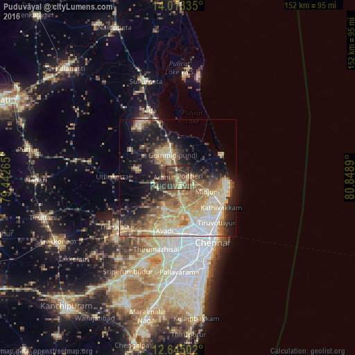
Analysis of Puduvāyal night lights 2016
Square area 10x10 km:
 0%
0%90-99
3.93%80-89
10.95%70-79
5.17%60-69
10.95%50-59
16.94%40-49
20.66%30-39
19.42%20-29
11.36%10-19
0.62%0-9
0%Square area 50x50 km:
4.6%90-99
6.37%80-89
10.15%70-79
3.89%60-69
5.09%50-59
7.85%40-49
5.48%30-39
5.56%20-29
7.59%10-19
12.48%0-9
30.94%Clear (daylight) street map image can be seen on geolist.org.
Map coordinates:
14° 0' 48.1" North, 79° 26' 33.5" East
13° 19' 48.5" North, 80° 8' 44.8" East
12° 38' 42.1" North, 80° 50' 56" East
Some cities around Puduvāyal sort by population:
• Kattivākkam
22.4 km =13.9 mi,  124°
124°
• Manali
22.4 km =13.9 mi,  144°
144°
• Ponneri
5.4 km =3.4 mi,  79°
79°
• Mīnjūr
13.4 km =8.3 mi,  114°
114°
• Nāravārikuppam
16 km =9.9 mi,  164°
164°
• Gummidipundi
9.5 km =5.9 mi,  335°
335°
• Chinnasekkadu
22.4 km =13.9 mi,  147°
147°
• Vellānūr
19.6 km =12.2 mi,  192°
192°
1259290 (p: 9,742)
Sources (retrieved 2019-11-25):
» Earth at Night: Flat Maps 2012, 2016