Sumberpucung night lights from space
Night Light of Sumberpucung (East Java) from space (Indonesia) Src. Average luminocity for 10x10km area is 11.1281% and for 50x50km: 13.0357%.
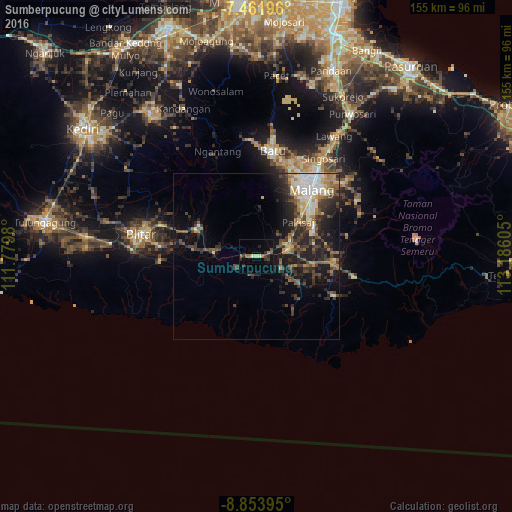

Analysis of Sumberpucung night lights 2016
Square area 10x10 km:
 0%
0%90-99
0.83%80-89
1.65%70-79
0.62%60-69
2.07%50-59
1.86%40-49
2.48%30-39
1.86%20-29
4.34%10-19
2.89%0-9
81.4%Square area 50x50 km:
1.21%90-99
2.21%80-89
1.18%70-79
1.45%60-69
1.94%50-59
1.76%40-49
2.94%30-39
3.13%20-29
4.63%10-19
7.86%0-9
71.69%Clear (daylight) street map image can be seen on geolist.org.
Map coordinates:
7° 27' 43.1" South, 111° 46' 47.3" East
8° 9' 30.8" South, 112° 28' 58.5" East
8° 51' 14.2" South, 113° 11' 9.8" East
Some cities around Sumberpucung sort by population:
• Malang
25.7 km =16 mi,  39°
39°
• Blitar
35.3 km =21.9 mi,  280°
280°
• Batu
32.5 km =20.2 mi,  8°
8°
• Singosari
35.8 km =22.2 mi,  34°
34°
• Kepanjen
10.4 km =6.5 mi,  72°
72°
• Pakisaji
16.3 km =10.1 mi,  51°
51°
• Dampit
29.9 km =18.6 mi,  101°
101°
• Gongdanglegi Kulon
16.9 km =10.5 mi, 96°
1626134 (p: 35,285)
Sources (retrieved 2019-11-25):
» Earth at Night: Flat Maps 2012, 2016