Tótkomlós night lights from space
Night Light of Tótkomlós (Bekes) from space (Hungary) Src. Average luminocity for 10x10km area is 1.2292% and for 50x50km: 1.6246%.
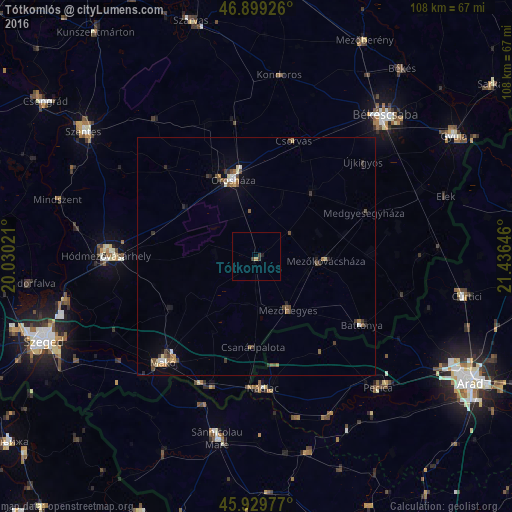
Analysis of Tótkomlós night lights 2016
Square area 10x10 km:
 0%
0%90-99
0%80-89
0%70-79
0.6%60-69
0%50-59
0%40-49
0.15%30-39
1.49%20-29
0.3%10-19
0.45%0-9
97.02%Square area 50x50 km:
0.09%90-99
0.21%80-89
0.14%70-79
0.21%60-69
0.22%50-59
0.35%40-49
0.29%30-39
0.45%20-29
0.3%10-19
0.26%0-9
97.48%Clear (daylight) street map image can be seen on geolist.org.
Map coordinates:
46° 53' 57.3" North, 20° 1' 48.8" East
46° 25' 0" North, 20° 43' 60" East
45° 55' 47.2" North, 21° 26' 11.3" East
Some cities around Tótkomlós sort by population:
• Orosháza
17.4 km =10.8 mi,  342°
342°
• Makó
29.4 km =18.3 mi,  220°
220°
• Nădlac, RO
27.8 km =17.3 mi,  177°
177°
• Mezőkovácsháza
14.2 km =8.8 mi,  97°
97°
• Battonya
26.3 km =16.3 mi,  124°
124°
• Mezőhegyes
12.8 km =8 mi,  150°
150°
• Csorvás
25.3 km =15.7 mi,  17°
17°
• Újkígyós
29.5 km =18.3 mi,  51°
51°
714548 (p: 6,497)
Sources (retrieved 2019-11-25):
» Earth at Night: Flat Maps 2012, 2016