Nádudvar night lights from space
Night Light of Nádudvar (Hajdú-Bihar) from space (Hungary) Src. Average luminocity for 10x10km area is 1.6051% and for 50x50km: 1.5861%.
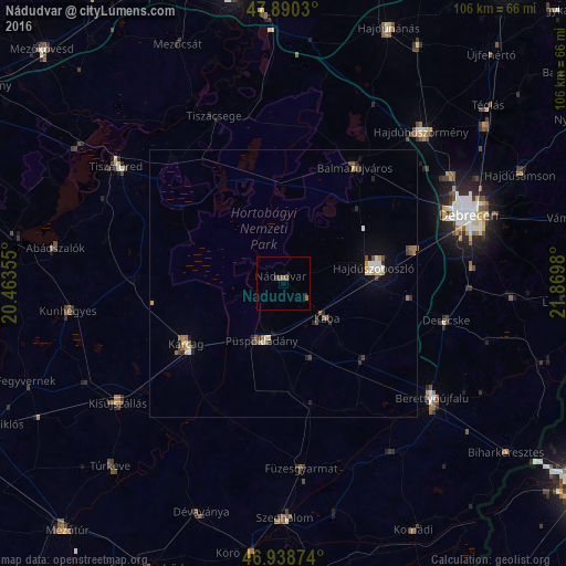
Analysis of Nádudvar night lights 2016
Square area 10x10 km:
 0%
0%90-99
0%80-89
0%70-79
0%60-69
0.57%50-59
1.14%40-49
0.57%30-39
0.57%20-29
0%10-19
0%0-9
97.16%Square area 50x50 km:
0.16%90-99
0.25%80-89
0.13%70-79
0.15%60-69
0.26%50-59
0.27%40-49
0.27%30-39
0.24%20-29
0.34%10-19
0.45%0-9
97.49%Clear (daylight) street map image can be seen on geolist.org.
Map coordinates:
47° 53' 25.1" North, 20° 27' 48.8" East
47° 25' 0" North, 21° 10' 0" East
46° 56' 19.5" North, 21° 52' 11.3" East
Some cities around Nádudvar sort by population:
• Hajdúszoboszló
17.9 km =11.1 mi,  78°
78°
• Karcag
20.8 km =12.9 mi,  237°
237°
• Balmazújváros
26.2 km =16.3 mi,  31°
31°
• Püspökladány
11.7 km =7.3 mi,  198°
198°
• Derecske
31 km =19.3 mi,  103°
103°
• Kaba
11.5 km =7.1 mi,  130°
130°
• Kunmadaras
27.6 km =17.1 mi,  273°
273°
• Egyek
31.3 km =19.4 mi,  320°
320°
717449 (p: 9,135)
Sources (retrieved 2019-11-25):
» Earth at Night: Flat Maps 2012, 2016