Gantiadi night lights from space
Night Light of Gantiadi (Abkhazia) from space (Georgia) Src. Average luminocity for 10x10km area is 12.1222% and for 50x50km: 6.9855%.
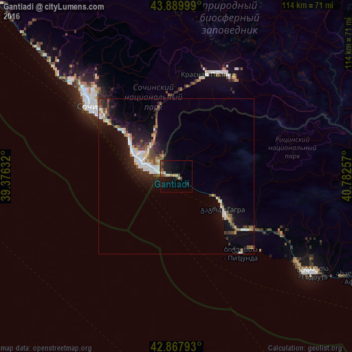
Analysis of Gantiadi night lights 2016
Square area 10x10 km:
 0%
0%90-99
2.22%80-89
0.16%70-79
2.38%60-69
1.9%50-59
1.27%40-49
3.33%30-39
0.16%20-29
3.97%10-19
14.13%0-9
70.48%Square area 50x50 km:
1.11%90-99
1.27%80-89
0.51%70-79
0.71%60-69
0.48%50-59
1.07%40-49
1.11%30-39
0.85%20-29
1.96%10-19
5.89%0-9
85.05%Clear (daylight) street map image can be seen on geolist.org.
Map coordinates:
43° 53' 24" North, 39° 22' 34.8" East
43° 22' 52" North, 40° 4' 46" East
42° 52' 4.5" North, 40° 46' 57.3" East
Some cities around Gantiadi sort by population:
• Sochi, RU
37.4 km =23.2 mi,  310°
310°
• Adler, RU
13.6 km =8.5 mi,  292°
292°
• Dagomys, RU
46.1 km =28.6 mi, 314°
• Khosta, RU
22.6 km =14 mi, 311°
• Kudepsta, RU
19.7 km =12.2 mi, 310°
• Bich’vinta
32.5 km =20.2 mi,  139°
139°
• Gagra
19.3 km =12 mi,  126°
126°
• Gudauta
53.5 km =33.2 mi,  124°
124°
614580 (p: 10,000)
Sources (retrieved 2019-11-25):
» Earth at Night: Flat Maps 2012, 2016