Saint-Omer night lights from space
Night Light of Saint-Omer (Hauts-de-France) from space (France) Src. Average luminocity for 10x10km area is 36.1163% and for 50x50km: 7.321%.
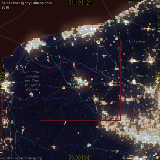
Analysis of Saint-Omer night lights 2016
Square area 10x10 km:
 6.42%
6.42%90-99
6.42%80-89
5.35%70-79
3.61%60-69
2.14%50-59
4.81%40-49
7.49%30-39
2.81%20-29
8.29%10-19
35.29%0-9
17.38%Square area 50x50 km:
0.8%90-99
0.8%80-89
0.78%70-79
0.64%60-69
0.65%50-59
0.94%40-49
1.37%30-39
0.9%20-29
2.31%10-19
7.71%0-9
83.11%Clear (daylight) street map image can be seen on geolist.org.
Map coordinates:
51° 11' 28" North, 1° 33' 28" East
50° 44' 54" North, 2° 15' 39.3" East
50° 18' 4.8" North, 2° 57' 50.5" East
Some cities around Saint-Omer sort by population:
• Hazebrouck
19.6 km =12.2 mi,  98°
98°
• Longuenesse
2.4 km =1.5 mi,  228°
228°
• Aire-sur-la-Lys
15.6 km =9.7 mi,  141°
141°
• Isbergues
19.7 km =12.2 mi,  134°
134°
• Arques
3.3 km =2.1 mi,  119°
119°
• Bourbourg
22.6 km =14 mi,  348°
348°
• Blendecques
3.8 km =2.4 mi,  152°
152°
• Wormhout
20.8 km =12.9 mi,  44°
44°
2977845 (p: 18,250)
Sources (retrieved 2019-11-25):
» Earth at Night: Flat Maps 2012, 2016