Saint-Jean-de-Luz night lights from space
Night Light of Saint-Jean-de-Luz (Nouvelle-Aquitaine) from space (France) Src. Average luminocity for 10x10km area is 22.0556% and for 50x50km: 11.1419%.
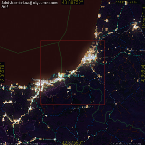
Analysis of Saint-Jean-de-Luz night lights 2016
Square area 10x10 km:
 2.06%
2.06%90-99
2.7%80-89
1.59%70-79
1.27%60-69
4.29%50-59
5.87%40-49
3.17%30-39
2.38%20-29
2.86%10-19
29.21%0-9
44.6%Square area 50x50 km:
1.86%90-99
1.94%80-89
0.88%70-79
0.98%60-69
1.39%50-59
1.69%40-49
1.25%30-39
1.3%20-29
4.19%10-19
9.22%0-9
75.3%Clear (daylight) street map image can be seen on geolist.org.
Map coordinates:
43° 53' 51.1" North, 2° 21' 56.8" West
43° 23' 19.4" North, 1° 39' 45.6" West
42° 52' 32.1" North, 0° 57' 34.3" West
Some cities around Saint-Jean-de-Luz sort by population:
• Irun, ES
11.6 km =7.2 mi,  241°
241°
• Anglet
15.5 km =9.6 mi,  50°
50°
• Biarritz
13.3 km =8.3 mi,  40°
40°
• Hondarribia, ES
11 km =6.8 mi,  258°
258°
• Hendaye
9.2 km =5.7 mi, 258°
• Urrugne
4.1 km =2.5 mi,  226°
226°
• Ciboure
1.3 km =0.8 mi, 238°
• Bidart
7.9 km =4.9 mi, 46°
2979309 (p: 14,514)
Sources (retrieved 2019-11-25):
» Earth at Night: Flat Maps 2012, 2016