Ciboure night lights from space
Night Light of Ciboure (Nouvelle-Aquitaine) from space (France) Src. Average luminocity for 10x10km area is 21.9587% and for 50x50km: 11.4956%.
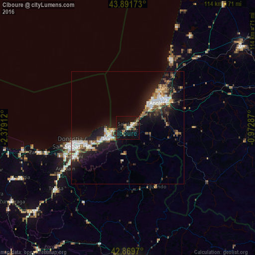
Analysis of Ciboure night lights 2016
Square area 10x10 km:
 2.06%
2.06%90-99
2.7%80-89
1.59%70-79
1.27%60-69
3.97%50-59
4.92%40-49
3.33%30-39
2.54%20-29
3.49%10-19
32.06%0-9
42.06%Square area 50x50 km:
2.02%90-99
2.05%80-89
0.89%70-79
0.98%60-69
1.4%50-59
1.71%40-49
1.28%30-39
1.33%20-29
4.3%10-19
9.37%0-9
74.68%Clear (daylight) street map image can be seen on geolist.org.
Map coordinates:
43° 53' 30.2" North, 2° 22' 44.8" West
43° 22' 58.3" North, 1° 40' 33.6" West
42° 52' 10.9" North, 0° 58' 22.3" West
Some cities around Ciboure sort by population:
• Irun, ES
10.4 km =6.5 mi,  241°
241°
• Anglet
16.8 km =10.4 mi,  51°
51°
• Biarritz
14.5 km =9 mi,  41°
41°
• Hondarribia, ES
9.8 km =6.1 mi,  260°
260°
• Saint-Jean-de-Luz
1.3 km =0.8 mi,  58°
58°
• Hendaye
8 km =5 mi, 261°
• Urrugne
2.8 km =1.7 mi,  221°
221°
• Bidart
9.2 km =5.7 mi, 48°
3024979 (p: 6,814)
Sources (retrieved 2019-11-25):
» Earth at Night: Flat Maps 2012, 2016