Pertuis night lights from space
Night Light of Pertuis (Provence-Alpes-Côte d'Azur) from space (France) Src. Average luminocity for 10x10km area is 19.0818% and for 50x50km: 12.621%.

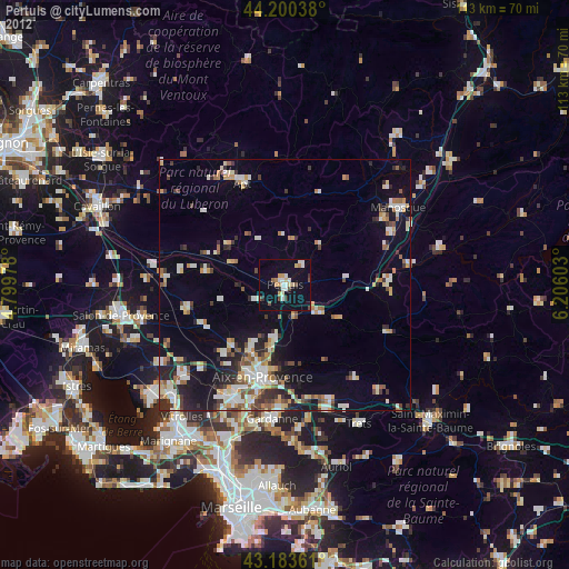
Analysis of Pertuis night lights 2016
Square area 10x10 km:
 1.52%
1.52%90-99
3.18%80-89
4.39%70-79
2.27%60-69
1.97%50-59
0.61%40-49
1.97%30-39
0.76%20-29
0.91%10-19
23.48%0-9
58.94%Square area 50x50 km:
1.41%90-99
2.28%80-89
1.56%70-79
1.47%60-69
1.33%50-59
1.8%40-49
1.8%30-39
1.8%20-29
3.06%10-19
8.06%0-9
75.43%Clear (daylight) street map image can be seen on geolist.org.
Map coordinates:
44° 12' 1.4" North, 4° 47' 59.2" East
43° 41' 38.9" North, 5° 30' 10.5" East
43° 11' 1" North, 6° 12' 21.7" East
Some cities around Pertuis sort by population:
• Aix-en-Provence
18.9 km =11.7 mi,  193°
193°
• Apt
22 km =13.7 mi,  337°
337°
• Lambesc
19.9 km =12.4 mi,  256°
256°
• Venelles
10.8 km =6.7 mi, 189°
• Éguilles
18.3 km =11.4 mi,  220°
220°
• La Roque-d’Anthéron
15.7 km =9.8 mi,  278°
278°
• Mallemort
26.3 km =16.3 mi, 279°
• Le Puy-Sainte-Réparade
6.4 km =4 mi,  238°
238°
2987825 (p: 19,926)
Sources (retrieved 2019-11-25):
» Earth at Night: Flat Maps 2012, 2016