Moyeuvre-Grande night lights from space
Night Light of Moyeuvre-Grande (Grand Est) from space (France) Src. Average luminocity for 10x10km area is 39.7848% and for 50x50km: 20.6759%.
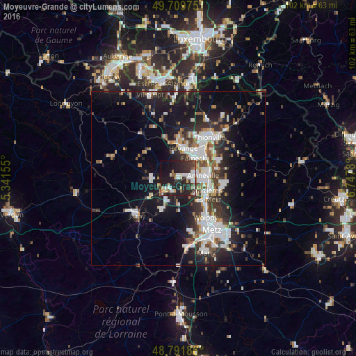
Analysis of Moyeuvre-Grande night lights 2016
Square area 10x10 km:
 7.22%
7.22%90-99
9.49%80-89
2.54%70-79
3.07%60-69
3.34%50-59
3.74%40-49
2.27%30-39
8.56%20-29
24.6%10-19
29.68%0-9
5.48%Square area 50x50 km:
4.64%90-99
4.56%80-89
1.27%70-79
1.47%60-69
1.75%50-59
2.07%40-49
2.39%30-39
3.9%20-29
6.53%10-19
14.5%0-9
56.92%Clear (daylight) street map image can be seen on geolist.org.
Map coordinates:
49° 42' 35.1" North, 5° 20' 29.6" East
49° 15' 10.6" North, 6° 2' 40.8" East
48° 47' 30.7" North, 6° 44' 52.1" East
Some cities around Moyeuvre-Grande sort by population:
• Hayange
8.5 km =5.3 mi,  8°
8°
• Fameck
6.9 km =4.3 mi,  42°
42°
• Rombas
3.6 km =2.2 mi,  96°
96°
• Amnéville
6.5 km =4 mi,  86°
86°
• Jœuf
3 km =1.9 mi,  222°
222°
• Homécourt
5.2 km =3.2 mi,  226°
226°
• Marange-Silvange
6.6 km =4.1 mi,  138°
138°
• Briey
7.6 km =4.7 mi,  266°
266°
2991264 (p: 9,099)
Sources (retrieved 2019-11-25):
» Earth at Night: Flat Maps 2012, 2016