Homécourt night lights from space
Night Light of Homécourt (Grand Est) from space (France) Src. Average luminocity for 10x10km area is 36.8503% and for 50x50km: 19.5799%.
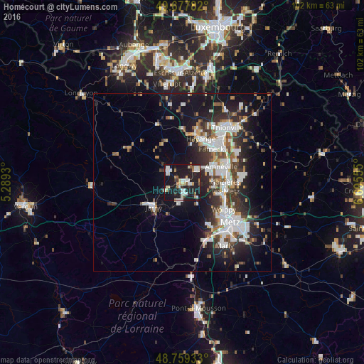
Analysis of Homécourt night lights 2016
Square area 10x10 km:
 6.15%
6.15%90-99
9.49%80-89
4.55%70-79
3.61%60-69
2.27%50-59
2.54%40-49
1.2%30-39
3.21%20-29
11.5%10-19
52.67%0-9
2.81%Square area 50x50 km:
4.51%90-99
4.4%80-89
1.2%70-79
1.43%60-69
1.71%50-59
1.87%40-49
2.22%30-39
3.7%20-29
5.91%10-19
13.01%0-9
60.03%Clear (daylight) street map image can be seen on geolist.org.
Map coordinates:
49° 40' 40.2" North, 5° 17' 21.5" East
49° 13' 14.6" North, 5° 59' 32.7" East
48° 45' 33.6" North, 6° 41' 44" East
Some cities around Homécourt sort by population:
• Fameck
12.1 km =7.5 mi,  44°
44°
• Rombas
8 km =5 mi,  66°
66°
• Amnéville
11 km =6.8 mi, 68°
• Moyeuvre-Grande
5.2 km =3.2 mi,  46°
46°
• Jarny
10.9 km =6.8 mi,  230°
230°
• Jœuf
2.3 km =1.4 mi, 51°
• Marange-Silvange
8.2 km =5.1 mi,  99°
99°
• Briey
5 km =3.1 mi,  309°
309°
3013195 (p: 6,971)
Sources (retrieved 2019-11-25):
» Earth at Night: Flat Maps 2012, 2016