Audenge night lights from space
Night Light of Audenge (Nouvelle-Aquitaine) from space (France) Src. Average luminocity for 10x10km area is 26.6667% and for 50x50km: 10.3093%.
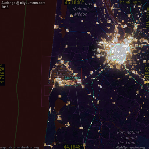
Analysis of Audenge night lights 2016
Square area 10x10 km:
 2.27%
2.27%90-99
3.18%80-89
1.52%70-79
4.09%60-69
4.09%50-59
5.45%40-49
3.64%30-39
2.88%20-29
2.88%10-19
48.48%0-9
21.52%Square area 50x50 km:
0.76%90-99
1.54%80-89
1.13%70-79
1.25%60-69
1.94%50-59
1.66%40-49
1.47%30-39
1.28%20-29
2%10-19
10.11%0-9
76.86%Clear (daylight) street map image can be seen on geolist.org.
Map coordinates:
45° 11' 4.6" North, 1° 42' 59.7" West
44° 41' 12.7" North, 1° 0' 48.4" West
44° 11' 5.3" North, 0° 18' 37.2" West
Some cities around Audenge sort by population:
• La Teste-de-Buch
12 km =7.5 mi,  237°
237°
• Gujan-Mestras
7.3 km =4.5 mi,  215°
215°
• Arcachon
12.7 km =7.9 mi,  255°
255°
• Andernos-les-Bains
9.7 km =6 mi,  312°
312°
• Biganos
5.6 km =3.5 mi,  145°
145°
• Lanton
2.7 km =1.7 mi,  318°
318°
• Le Teich
6.2 km =3.9 mi,  185°
185°
• Mios
11.1 km =6.9 mi, 145°
3036256 (p: 5,522)
Sources (retrieved 2019-11-25):
» Earth at Night: Flat Maps 2012, 2016