Tyrnävä night lights from space
Night Light of Tyrnävä (Northern Ostrobothnia) from space (Finland) Src. Average luminocity for 10x10km area is 8.2236% and for 50x50km: 5.0584%.
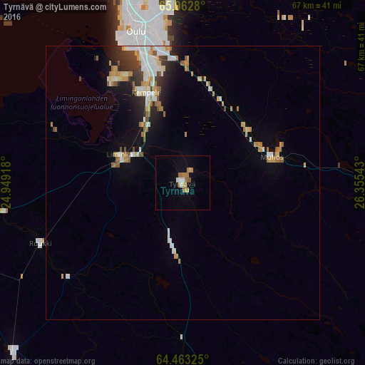
Analysis of Tyrnävä night lights 2016
Square area 10x10 km:
 0.91%
0.91%90-99
0.91%80-89
1.27%70-79
1%60-69
2.64%50-59
1.27%40-49
0%30-39
0%20-29
0%10-19
1.09%0-9
90.91%Square area 50x50 km:
0.76%90-99
0.99%80-89
0.6%70-79
0.76%60-69
0.77%50-59
0.51%40-49
0.36%30-39
0.55%20-29
1%10-19
2.09%0-9
91.62%Clear (daylight) street map image can be seen on geolist.org.
Map coordinates:
65° 3' 46.1" North, 24° 56' 57" East
64° 45' 52.9" North, 25° 39' 8.3" East
64° 27' 47.7" North, 26° 21' 19.5" East
Some cities around Tyrnävä sort by population:
• Oulu
28.9 km =18 mi,  342°
342°
• Raahe
56.2 km =34.9 mi,  260°
260°
• Haukipudas
47.9 km =29.8 mi, 342°
• Kempele
17.9 km =11.1 mi, 336°
• Kiiminki
41.3 km =25.7 mi,  9°
9°
• Oulunsalo
22.1 km =13.7 mi,  328°
328°
• Muhos
16.8 km =10.4 mi,  73°
73°
• Liminka
12.3 km =7.6 mi,  294°
294°
633541 (p: 5,636)
Sources (retrieved 2019-11-25):
» Earth at Night: Flat Maps 2012, 2016