Hanko night lights from space
Night Light of Hanko (Uusimaa) from space (Finland) Src. Average luminocity for 10x10km area is 16.4845% and for 50x50km: 0.8842%.
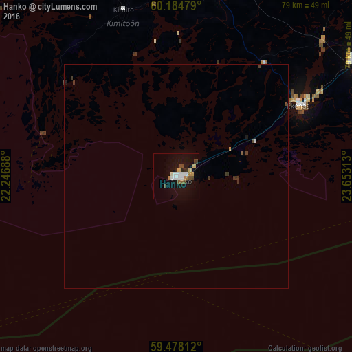
Analysis of Hanko night lights 2016
Square area 10x10 km:
100  2.69%
2.69%
90-99 3.1%
80-89 1.96%
70-79 1.34%
60-69 1.86%
50-59 1.34%
40-49 3.2%
30-39 0.83%
20-29 0.93%
10-19 16.01%
0-9 66.74%
2.69%90-99
3.1%80-89
1.96%70-79
1.34%60-69
1.86%50-59
1.34%40-49
3.2%30-39
0.83%20-29
0.93%10-19
16.01%0-9
66.74%Square area 50x50 km:
100 0.12%
90-99 0.13%
80-89 0.08%
70-79 0.07%
60-69 0.08%
50-59 0.07%
40-49 0.18%
30-39 0.21%
20-29 0.06%
10-19 0.68%
0-9 98.3%
0.12%90-99
0.13%80-89
0.08%70-79
0.07%60-69
0.08%50-59
0.07%40-49
0.18%30-39
0.21%20-29
0.06%10-19
0.68%0-9
98.3%Clear (daylight) street map image can be seen on geolist.org.
Map coordinates:
60° 11' 5.2" North, 22° 14' 48.8" East
59° 49' 60" North, 22° 57' 0" East
59° 28' 41.2" North, 23° 39' 11.3" East
Some cities around Hanko sort by population:
• Salo
62 km =38.5 mi,  9°
9°
• Väståboland
63.2 km =39.3 mi,  325°
325°
• Ekenäs
31.2 km =19.4 mi,  59°
59°
• Halikko
63.4 km =39.4 mi, 6°
• Karis
47.7 km =29.6 mi, 56°
• Perniö
42 km =26.1 mi, 14°
• Pohja
43.5 km =27 mi,  47°
47°
• Ingå
63.3 km =39.3 mi,  68°
68°
659101 (p: 9,962)
Sources (retrieved 2019-11-25):
» Earth at Night: Flat Maps 2012, 2016