Velez Rubio night lights from space
Night Light of Velez Rubio (Andalusia) from space (Spain) Src. Average luminocity for 10x10km area is 2.9286% and for 50x50km: 1.0172%.
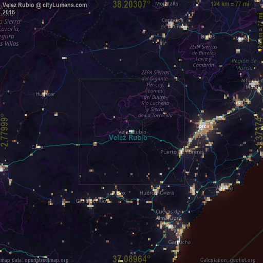
Analysis of Velez Rubio night lights 2016
Square area 10x10 km:
 0%
0%90-99
0.68%80-89
0%70-79
0.68%60-69
0%50-59
0.51%40-49
1.53%30-39
0.34%20-29
1.36%10-19
0%0-9
94.9%Square area 50x50 km:
0.05%90-99
0.1%80-89
0.13%70-79
0.1%60-69
0.12%50-59
0.33%40-49
0.14%30-39
0.15%20-29
0.18%10-19
0.3%0-9
98.4%Clear (daylight) street map image can be seen on geolist.org.
Map coordinates:
38° 12' 11.1" North, 2° 46' 48" West
37° 38' 54.4" North, 2° 4' 36.7" West
37° 5' 22.7" North, 1° 22' 25.5" West
Some cities around Velez Rubio sort by population:
• Lorca
33.1 km =20.6 mi,  85°
85°
• Huércal-Overa
31.2 km =19.4 mi,  157°
157°
• Puerto Lumbreras
25.4 km =15.8 mi,  111°
111°
• Cuevas del Almanzora
42.7 km =26.5 mi, 156°
• Albox
29.6 km =18.4 mi,  192°
192°
• Pulpí
39.4 km =24.5 mi,  131°
131°
• Olula del Río
38 km =23.6 mi,  210°
210°
• Macael
40.2 km =25 mi, 209°
2509768 (p: 7,045)
Sources (retrieved 2019-11-25):
» Earth at Night: Flat Maps 2012, 2016