Macael night lights from space
Night Light of Macael (Andalusia) from space (Spain) Src. Average luminocity for 10x10km area is 13.4075% and for 50x50km: 2.1107%.
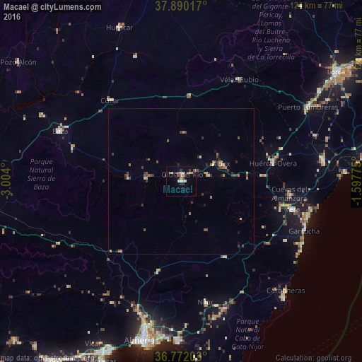
Analysis of Macael night lights 2016
Square area 10x10 km:
 1.14%
1.14%90-99
3.57%80-89
0.81%70-79
2.11%60-69
2.44%50-59
0.16%40-49
2.6%30-39
1.46%20-29
1.3%10-19
0.65%0-9
83.77%Square area 50x50 km:
0.05%90-99
0.25%80-89
0.22%70-79
0.25%60-69
0.42%50-59
0.35%40-49
0.44%30-39
0.53%20-29
0.38%10-19
0.27%0-9
96.83%Clear (daylight) street map image can be seen on geolist.org.
Map coordinates:
37° 53' 24.6" North, 3° 0' 14.4" West
37° 19' 59.4" North, 2° 18' 3.1" West
36° 46' 19.3" North, 1° 35' 51.9" West
Some cities around Macael sort by population:
• Níjar
41.6 km =25.8 mi,  168°
168°
• Huércal-Overa
32.2 km =20 mi,  78°
78°
• Vera
40.3 km =25 mi,  104°
104°
• Cuevas del Almanzora
37.2 km =23.1 mi, 96°
• Albox
14.7 km =9.1 mi,  65°
65°
• La Mojonera
12.9 km =8 mi,  249°
249°
• Velez Rubio
40.2 km =25 mi,  29°
29°
• Olula del Río
2.4 km =1.5 mi,  7°
7°
2514360 (p: 6,090)
Sources (retrieved 2019-11-25):
» Earth at Night: Flat Maps 2012, 2016