Torrijos night lights from space
Night Light of Torrijos (Castille-La Mancha) from space (Spain) Src. Average luminocity for 10x10km area is 22.3793% and for 50x50km: 7.6859%.
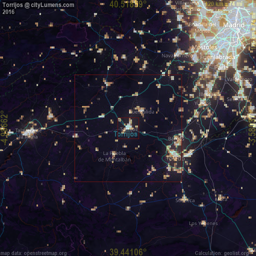
Analysis of Torrijos night lights 2016
Square area 10x10 km:
 2.38%
2.38%90-99
3.74%80-89
3.23%70-79
2.89%60-69
4.08%50-59
1.87%40-49
1.02%30-39
0.51%20-29
2.38%10-19
30.95%0-9
46.94%Square area 50x50 km:
0.47%90-99
0.9%80-89
1.12%70-79
1.18%60-69
1.56%50-59
1.03%40-49
0.68%30-39
0.75%20-29
1.78%10-19
4.09%0-9
86.43%Clear (daylight) street map image can be seen on geolist.org.
Map coordinates:
40° 31' 6.9" North, 4° 59' 11.8" West
39° 58' 55" North, 4° 17' 0.6" West
39° 26' 27.8" North, 3° 34' 49.3" West
Some cities around Torrijos sort by population:
• Toledo
26.2 km =16.3 mi,  121°
121°
• Fuensalida
10.2 km =6.3 mi,  39°
39°
• Bargas
22.9 km =14.2 mi,  101°
101°
• La Puebla de Montalbán
14.7 km =9.1 mi,  206°
206°
• El Álamo
37 km =23 mi, 41°
• Yuncos
37 km =23 mi,  71°
71°
• Villa del Prado
33 km =20.5 mi,  356°
356°
• Olías del Rey
25.6 km =15.9 mi, 99°
2510249 (p: 13,117)
Sources (retrieved 2019-11-25):
» Earth at Night: Flat Maps 2012, 2016