Bargas night lights from space
Night Light of Bargas (Castille-La Mancha) from space (Spain) Src. Average luminocity for 10x10km area is 24.2772% and for 50x50km: 12.7839%.
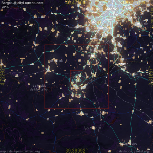
Analysis of Bargas night lights 2016
Square area 10x10 km:
 1.53%
1.53%90-99
3.74%80-89
2.89%70-79
4.76%60-69
4.93%50-59
2.21%40-49
0.34%30-39
0.68%20-29
8.84%10-19
33.16%0-9
36.9%Square area 50x50 km:
0.92%90-99
1.77%80-89
1.82%70-79
1.76%60-69
2.21%50-59
1.34%40-49
1.23%30-39
1.29%20-29
3.81%10-19
13.09%0-9
70.77%Clear (daylight) street map image can be seen on geolist.org.
Map coordinates:
40° 28' 41.1" North, 4° 43' 22.5" West
39° 56' 28.1" North, 4° 1' 11.2" West
39° 23' 59.7" North, 3° 19' 0" West
Some cities around Bargas sort by population:
• Toledo
9.2 km =5.7 mi,  181°
181°
• Illescas
24.9 km =15.5 mi,  36°
36°
• Torrijos
22.9 km =14.2 mi,  281°
281°
• Sonseca
29.6 km =18.4 mi,  172°
172°
• Fuensalida
20.2 km =12.6 mi,  307°
307°
• Yuncos
20.5 km =12.7 mi, 38°
• Olías del Rey
2.8 km =1.7 mi,  82°
82°
• Añover de Tajo
22.3 km =13.9 mi, 76°
2521316 (p: 7,731)
Sources (retrieved 2019-11-25):
» Earth at Night: Flat Maps 2012, 2016