Punta Umbría night lights from space
Night Light of Punta Umbría (Andalusia) from space (Spain) Src. Average luminocity for 10x10km area is 36.0935% and for 50x50km: 10.1557%.
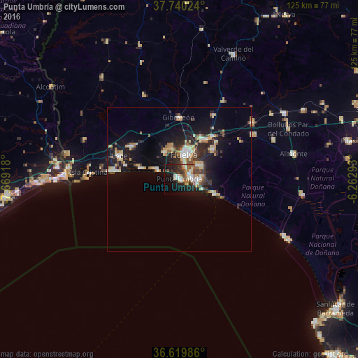
Analysis of Punta Umbría night lights 2016
Square area 10x10 km:
 6.8%
6.8%90-99
7.82%80-89
2.04%70-79
4.59%60-69
4.42%50-59
3.74%40-49
5.61%30-39
5.27%20-29
11.39%10-19
26.36%0-9
21.94%Square area 50x50 km:
1.26%90-99
1.33%80-89
1.52%70-79
1.32%60-69
1.27%50-59
1%40-49
1.09%30-39
1.77%20-29
3.28%10-19
8.25%0-9
77.91%Clear (daylight) street map image can be seen on geolist.org.
Map coordinates:
37° 44' 24.9" North, 7° 40' 9" West
37° 10' 55.7" North, 6° 57' 57.8" West
36° 37' 11.5" North, 6° 15' 46.5" West
Some cities around Punta Umbría sort by population:
• Huelva
9.6 km =6 mi,  13°
13°
• Lepe
22.6 km =14 mi,  290°
290°
• Moguer
15.3 km =9.5 mi,  47°
47°
• Aljaraque
11 km =6.8 mi,  332°
332°
• Cartaya
19.7 km =12.2 mi,  303°
303°
• Gibraleón
21.6 km =13.4 mi,  359°
359°
• Palos de la Frontera
8.6 km =5.3 mi, 47°
• San Juan del Puerto
18.6 km =11.6 mi,  36°
36°
2565056 (p: 14,708)
Sources (retrieved 2019-11-25):
» Earth at Night: Flat Maps 2012, 2016