Gibraleón night lights from space
Night Light of Gibraleón (Andalusia) from space (Spain) Src. Average luminocity for 10x10km area is 7.0341% and for 50x50km: 10.1341%.
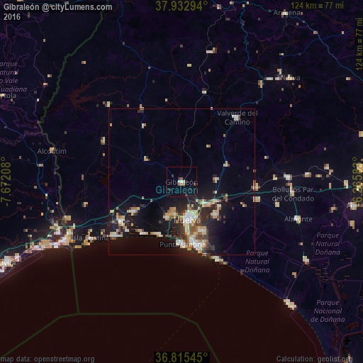
Analysis of Gibraleón night lights 2016
Square area 10x10 km:
 0.49%
0.49%90-99
0.81%80-89
0.49%70-79
0.16%60-69
1.14%50-59
1.46%40-49
0.16%30-39
2.11%20-29
2.27%10-19
3.41%0-9
87.5%Square area 50x50 km:
1.25%90-99
1.36%80-89
1.59%70-79
1.42%60-69
1.24%50-59
1.03%40-49
1.15%30-39
1.68%20-29
3.23%10-19
7.39%0-9
78.65%Clear (daylight) street map image can be seen on geolist.org.
Map coordinates:
37° 55' 58.6" North, 7° 40' 19.5" West
37° 22' 34.6" North, 6° 58' 8.2" West
36° 48' 55.6" North, 6° 15' 57" West
Some cities around Gibraleón sort by population:
• Huelva
12.5 km =7.8 mi,  168°
168°
• Moguer
16.1 km =10 mi,  134°
134°
• Aljaraque
12.8 km =8 mi,  202°
202°
• Cartaya
19.2 km =11.9 mi,  236°
236°
• Punta Umbría
21.6 km =13.4 mi,  179°
179°
• Palos de la Frontera
17.1 km =10.6 mi,  157°
157°
• Trigueros
12.6 km =7.8 mi,  85°
85°
• San Juan del Puerto
13.1 km =8.1 mi,  120°
120°
2517236 (p: 12,258)
Sources (retrieved 2019-11-25):
» Earth at Night: Flat Maps 2012, 2016