Pizarra night lights from space
Night Light of Pizarra (Andalusia) from space (Spain) Src. Average luminocity for 10x10km area is 7.7885% and for 50x50km: 13.2948%.
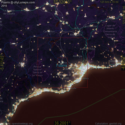
Analysis of Pizarra night lights 2016
Square area 10x10 km:
 0.35%
0.35%90-99
0.52%80-89
1.92%70-79
0%60-69
0.7%50-59
1.05%40-49
1.4%30-39
2.1%20-29
0.35%10-19
0.17%0-9
91.43%Square area 50x50 km:
2.42%90-99
2.49%80-89
1.11%70-79
1.39%60-69
2.12%50-59
1.2%40-49
1.8%30-39
2.19%20-29
3.91%10-19
7.88%0-9
73.49%Clear (daylight) street map image can be seen on geolist.org.
Map coordinates:
37° 19' 35.9" North, 5° 24' 41.2" West
36° 45' 55.5" North, 4° 42' 30" West
36° 12' 0.4" North, 4° 0' 18.7" West
Some cities around Pizarra sort by population:
• Mijas
19.9 km =12.4 mi,  161°
161°
• Torremolinos
24.6 km =15.3 mi,  130°
130°
• Benalmádena
22.4 km =13.9 mi,  147°
147°
• Alhaurín de la Torre
17.3 km =10.7 mi, 130°
• Alhaurín el Grande
13.7 km =8.5 mi,  172°
172°
• Coín
12.5 km =7.8 mi,  199°
199°
• Cártama
9.1 km =5.7 mi, 132°
• Alora
6.5 km =4 mi,  2°
2°
2512490 (p: 7,345)
Sources (retrieved 2019-11-25):
» Earth at Night: Flat Maps 2012, 2016