Pilas night lights from space
Night Light of Pilas (Andalusia) from space (Spain) Src. Average luminocity for 10x10km area is 15.1136% and for 50x50km: 11.898%.
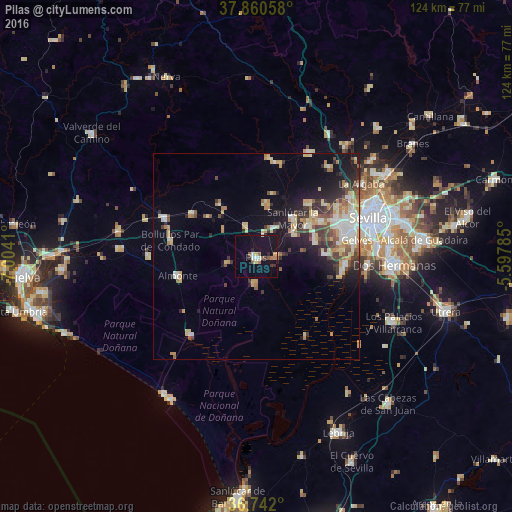
Analysis of Pilas night lights 2016
Square area 10x10 km:
 1.62%
1.62%90-99
1.14%80-89
1.3%70-79
1.14%60-69
2.27%50-59
3.25%40-49
0%30-39
2.27%20-29
1.95%10-19
19.48%0-9
65.58%Square area 50x50 km:
1.48%90-99
1.6%80-89
2.32%70-79
1.8%60-69
1.31%50-59
1.24%40-49
1.49%30-39
1.96%20-29
2.43%10-19
6.89%0-9
77.48%Clear (daylight) street map image can be seen on geolist.org.
Map coordinates:
37° 51' 38.1" North, 7° 0' 14.8" West
37° 18' 12.1" North, 6° 18' 3.5" West
36° 44' 31.2" North, 5° 35' 52.3" West
Some cities around Pilas sort by population:
• Almonte
19.6 km =12.2 mi,  257°
257°
• Sanlúcar la Mayor
12.7 km =7.9 mi,  42°
42°
• Espartinas
17.8 km =11.1 mi,  60°
60°
• Olivares
18.1 km =11.2 mi,  45°
45°
• Bollullos de la Mitación
15 km =9.3 mi,  74°
74°
• Benacazón
10.7 km =6.6 mi, 59°
• Umbrete
14.5 km =9 mi, 59°
• Villanueva del Ariscal
17.5 km =10.9 mi, 53°
2512578 (p: 13,386)
Sources (retrieved 2019-11-25):
» Earth at Night: Flat Maps 2012, 2016