Bollullos de la Mitación night lights from space
Night Light of Bollullos de la Mitación (Andalusia) from space (Spain) Src. Average luminocity for 10x10km area is 43.9221% and for 50x50km: 23.8152%.
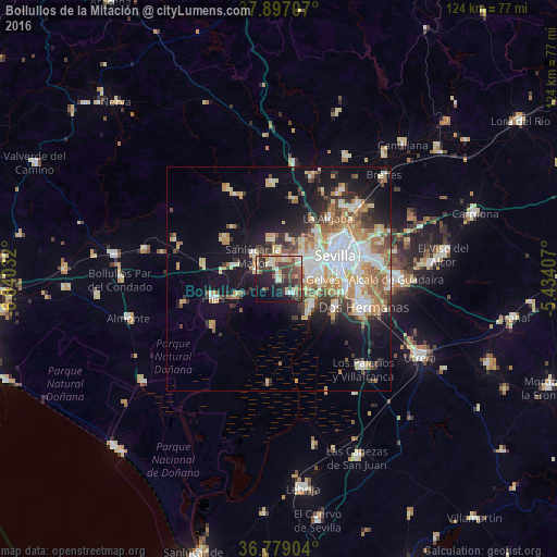
Analysis of Bollullos de la Mitación night lights 2016
Square area 10x10 km:
 3.08%
3.08%90-99
6.98%80-89
10.23%70-79
3.73%60-69
4.06%50-59
6.33%40-49
14.61%30-39
11.69%20-29
11.69%10-19
18.51%0-9
9.09%Square area 50x50 km:
4.47%90-99
3.94%80-89
3.61%70-79
3.51%60-69
3.62%50-59
2.66%40-49
2.58%30-39
3.4%20-29
4.03%10-19
10.74%0-9
57.46%Clear (daylight) street map image can be seen on geolist.org.
Map coordinates:
37° 53' 49.5" North, 6° 50' 25.2" West
37° 20' 24.5" North, 6° 8' 13.9" West
36° 46' 44.5" North, 5° 26' 2.7" West
Some cities around Bollullos de la Mitación sort by population:
• Mairena del Aljarafe
6.5 km =4 mi,  85°
85°
• Bormujos
6.8 km =4.2 mi,  57°
57°
• Gines
7.4 km =4.6 mi,  45°
45°
• Sanlúcar la Mayor
7.9 km =4.9 mi,  312°
312°
• Espartinas
4.7 km =2.9 mi,  12°
12°
• Benacazón
5.4 km =3.4 mi,  285°
285°
• Umbrete
3.7 km =2.3 mi,  329°
329°
• Villanueva del Ariscal
6.2 km =3.9 mi,  357°
357°
2520870 (p: 6,499)
Sources (retrieved 2019-11-25):
» Earth at Night: Flat Maps 2012, 2016