La Puebla del Río night lights from space
Night Light of La Puebla del Río (Andalusia) from space (Spain) Src. Average luminocity for 10x10km area is 26.1497% and for 50x50km: 24.2047%.
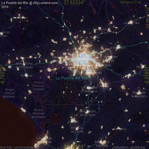
Analysis of La Puebla del Río night lights 2016
Square area 10x10 km:
 2.21%
2.21%90-99
3.57%80-89
2.04%70-79
4.08%60-69
1.02%50-59
1.53%40-49
6.97%30-39
10.71%20-29
11.39%10-19
23.47%0-9
32.99%Square area 50x50 km:
4.59%90-99
4.02%80-89
3.5%70-79
3.4%60-69
3.7%50-59
2.83%40-49
2.85%30-39
3.89%20-29
4.59%10-19
10.46%0-9
56.17%Clear (daylight) street map image can be seen on geolist.org.
Map coordinates:
37° 49' 31.2" North, 6° 45' 56.7" West
37° 16' 4.3" North, 6° 3' 45.5" West
36° 42' 22.5" North, 5° 21' 34.2" West
Some cities around La Puebla del Río sort by population:
• Dos Hermanas
12.7 km =7.9 mi,  82°
82°
• Mairena del Aljarafe
8.5 km =5.3 mi,  359°
359°
• Coria del Río
2.3 km =1.4 mi,  18°
18°
• Tomares
11.8 km =7.3 mi,  7°
7°
• San Juan de Aznalfarache
10.3 km =6.4 mi, 12°
• Bormujos
11.8 km =7.3 mi, 355°
• Gelves
8.1 km =5 mi, 23°
• Bollullos de la Mitación
10.4 km =6.5 mi,  320°
320°
2515620 (p: 12,143)
Sources (retrieved 2019-11-25):
» Earth at Night: Flat Maps 2012, 2016