Fuente-Álamo de Murcia night lights from space
Night Light of Fuente-Álamo de Murcia (Murcia) from space (Spain) Src. Average luminocity for 10x10km area is 21.6769% and for 50x50km: 19.3347%.
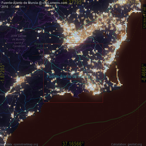
Analysis of Fuente-Álamo de Murcia night lights 2016
Square area 10x10 km:
 1.36%
1.36%90-99
2.38%80-89
3.91%70-79
1.36%60-69
1.19%50-59
3.74%40-49
2.72%30-39
3.4%20-29
5.44%10-19
36.73%0-9
37.76%Square area 50x50 km:
1.75%90-99
2.58%80-89
2.44%70-79
2.1%60-69
3%50-59
2.01%40-49
2.32%30-39
4.18%20-29
7.17%10-19
16.9%0-9
55.53%Clear (daylight) street map image can be seen on geolist.org.
Map coordinates:
38° 16' 40.6" North, 1° 52' 22.3" West
37° 43' 26" North, 1° 10' 11" West
37° 9' 56.4" North, 0° 27' 59.8" West
Some cities around Fuente-Álamo de Murcia sort by population:
• Cartagena
20.9 km =13 mi,  129°
129°
• Alcantarilla
27.6 km =17.1 mi,  351°
351°
• Mazarrón
18.9 km =11.7 mi,  222°
222°
• Torre-Pacheco
19.1 km =11.9 mi,  83°
83°
• Alhama de Murcia
26.5 km =16.5 mi,  302°
302°
• Sangonera la Verde
23 km =14.3 mi, 351°
• El Plan
15.8 km =9.8 mi,  121°
121°
• Los Gabatos
18 km =11.2 mi, 123°
2517574 (p: 9,500)
Sources (retrieved 2019-11-25):
» Earth at Night: Flat Maps 2012, 2016