Castro de Rei night lights from space
Night Light of Castro de Rei (Galicia) from space (Spain) Src. Average luminocity for 10x10km area is 0.5197% and for 50x50km: 2.7527%.
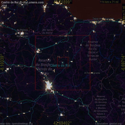
Analysis of Castro de Rei night lights 2016
Square area 10x10 km:
 0%
0%90-99
0%80-89
0%70-79
0%60-69
0%50-59
0%40-49
0.3%30-39
0.91%20-29
0%10-19
0%0-9
98.79%Square area 50x50 km:
0.53%90-99
0.62%80-89
0.36%70-79
0.21%60-69
0.16%50-59
0.19%40-49
0.29%30-39
0.36%20-29
0.79%10-19
1.92%0-9
94.59%Clear (daylight) street map image can be seen on geolist.org.
Map coordinates:
43° 43' 8.4" North, 8° 6' 12.2" West
43° 12' 31.2" North, 7° 24' 0.9" West
42° 41' 38.5" North, 6° 41' 49.7" West
Some cities around Castro de Rei sort by population:
• Lugo
25.5 km =15.8 mi,  209°
209°
• Vilalba
24.8 km =15.4 mi,  293°
293°
• Mos
13.5 km =8.4 mi,  244°
244°
• As Pontes de García Rodríguez
45.5 km =28.3 mi,  306°
306°
• Foz
41.8 km =26 mi,  16°
16°
• Ribadeo
46.7 km =29 mi,  38°
38°
• Guitiriz
40.3 km =25 mi,  265°
265°
• Outeiro de Rei
21.1 km =13.1 mi, 235°
3125667 (p: 5,685)
Sources (retrieved 2019-11-25):
» Earth at Night: Flat Maps 2012, 2016