Brunete night lights from space
Night Light of Brunete (Madrid) from space (Spain) Src. Average luminocity for 10x10km area is 29.2228% and for 50x50km: 36.6674%.
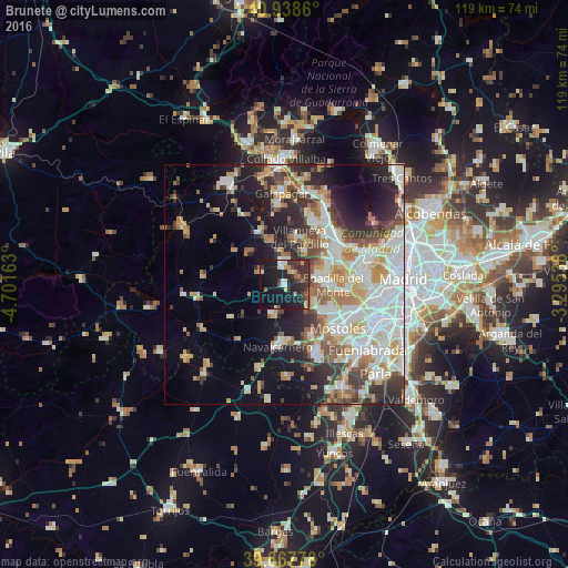
Analysis of Brunete night lights 2016
Square area 10x10 km:
 2.38%
2.38%90-99
4.42%80-89
2.72%70-79
2.89%60-69
2.55%50-59
2.04%40-49
3.4%30-39
10.88%20-29
16.5%10-19
37.93%0-9
14.29%Square area 50x50 km:
8.27%90-99
9.01%80-89
3.74%70-79
4.88%60-69
4.26%50-59
3.67%40-49
3.67%30-39
4.96%20-29
7.31%10-19
12.18%0-9
38.05%Clear (daylight) street map image can be seen on geolist.org.
Map coordinates:
40° 56' 19" North, 4° 42' 5.9" West
40° 24' 19.2" North, 3° 59' 54.6" West
39° 52' 4" North, 3° 17' 43.4" West
Some cities around Brunete sort by population:
• Majadahonda
13.1 km =8.1 mi,  54°
54°
• Boadilla del Monte
10.2 km =6.3 mi,  90°
90°
• Villaviciosa de Odón
9.6 km =6 mi,  123°
123°
• Navalcarnero
13 km =8.1 mi,  185°
185°
• Villanueva de la Cañada
4.6 km =2.9 mi,  353°
353°
• Villanueva del Pardillo
9.9 km =6.2 mi,  17°
17°
• Valdemorillo
12.1 km =7.5 mi,  331°
331°
• Sevilla La Nueva
6.8 km =4.2 mi,  200°
200°
3127588 (p: 7,799)
Sources (retrieved 2019-11-25):
» Earth at Night: Flat Maps 2012, 2016