Seefeld night lights from space
Night Light of Seefeld (Bavaria) from space (Germany) Src. Average luminocity for 10x10km area is 1.5938% and for 50x50km: 9.7489%.
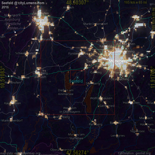
Analysis of Seefeld night lights 2016
Square area 10x10 km:
 0%
0%90-99
0%80-89
0.57%70-79
0%60-69
0%50-59
0%40-49
0%30-39
1.14%20-29
1.14%10-19
0.57%0-9
96.59%Square area 50x50 km:
1.59%90-99
1.64%80-89
1.07%70-79
0.95%60-69
1.59%50-59
1.58%40-49
1.2%30-39
1.17%20-29
2.64%10-19
6.09%0-9
80.49%Clear (daylight) street map image can be seen on geolist.org.
Map coordinates:
48° 30' 11.1" North, 10° 30' 39" East
48° 2' 6.2" North, 11° 12' 50.2" East
47° 33' 45.9" North, 11° 55' 1.5" East
Some cities around Seefeld sort by population:
• Starnberg
10.4 km =6.5 mi,  110°
110°
• Gauting
12.7 km =7.9 mi,  72°
72°
• Gilching
10 km =6.2 mi,  36°
36°
• Dießen am Ammersee
12.5 km =7.8 mi,  221°
221°
• Herrsching am Ammersee
4.9 km =3 mi,  214°
214°
• Tutzing
14.8 km =9.2 mi,  160°
160°
• Pöcking
9.9 km =6.2 mi,  139°
139°
• Weßling
5.1 km =3.2 mi,  30°
30°
2833866 (p: 7,033)
Sources (retrieved 2019-11-25):
» Earth at Night: Flat Maps 2012, 2016