Saulgau night lights from space
Night Light of Saulgau (Baden-Württemberg) from space (Germany) Src. Average luminocity for 10x10km area is 2.5597% and for 50x50km: 1.6228%.
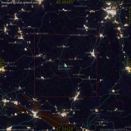
Analysis of Saulgau night lights 2016
Square area 10x10 km:
 0%
0%90-99
0.85%80-89
0.43%70-79
0.43%60-69
0%50-59
0.57%40-49
0%30-39
0.99%20-29
0.14%10-19
0.57%0-9
96.02%Square area 50x50 km:
0.21%90-99
0.23%80-89
0.14%70-79
0.06%60-69
0.21%50-59
0.34%40-49
0.35%30-39
0.27%20-29
0.27%10-19
0.61%0-9
97.3%Clear (daylight) street map image can be seen on geolist.org.
Map coordinates:
48° 29' 5.8" North, 8° 47' 51.1" East
48° 1' 0.3" North, 9° 30' 2.3" East
47° 32' 39.4" North, 10° 12' 13.6" East
Some cities around Saulgau sort by population:
• Pfullendorf
20.7 km =12.9 mi,  240°
240°
• Riedlingen
15.4 km =9.6 mi,  353°
353°
• Mengen
13.2 km =8.2 mi,  286°
286°
• Aulendorf
12.5 km =7.8 mi,  125°
125°
• Bad Schussenried
11.7 km =7.3 mi,  96°
96°
• Ostrach
11.5 km =7.1 mi,  229°
229°
• Ertingen
9.6 km =6 mi,  344°
344°
• Krauchenwies
18.8 km =11.7 mi,  269°
269°
2841125 (p: 17,911)
Sources (retrieved 2019-11-25):
» Earth at Night: Flat Maps 2012, 2016