Lenggries night lights from space
Night Light of Lenggries (Bavaria) from space (Germany) Src. Average luminocity for 10x10km area is 0.8065% and for 50x50km: 1.2023%.
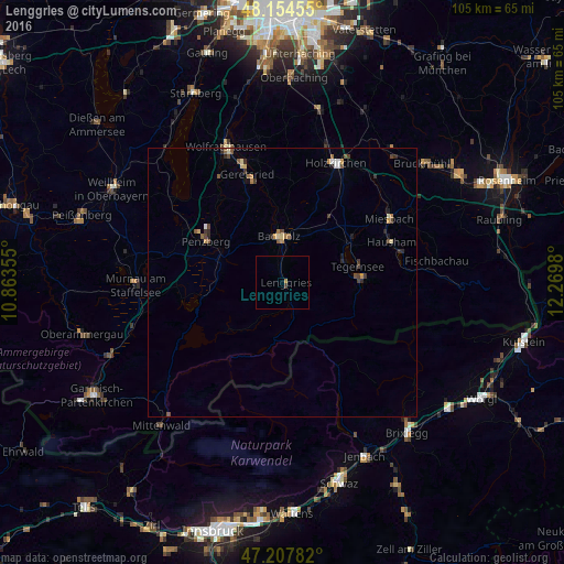
Analysis of Lenggries night lights 2016
Square area 10x10 km:
 0%
0%90-99
0%80-89
0%70-79
0.45%60-69
0.15%50-59
0%40-49
0.15%30-39
0.45%20-29
0%10-19
0%0-9
98.81%Square area 50x50 km:
0.07%90-99
0.11%80-89
0.14%70-79
0.21%60-69
0.2%50-59
0.2%40-49
0.26%30-39
0.25%20-29
0.28%10-19
0.15%0-9
98.12%Clear (daylight) street map image can be seen on geolist.org.
Map coordinates:
48° 9' 16.4" North, 10° 51' 48.8" East
47° 40' 60" North, 11° 34' 0" East
47° 12' 28.2" North, 12° 16' 11.3" East
Some cities around Lenggries sort by population:
• Geretsried
20.4 km =12.7 mi,  341°
341°
• Bad Tölz
8.7 km =5.4 mi,  356°
356°
• Penzberg
16.2 km =10.1 mi,  298°
298°
• Hausham
21.7 km =13.5 mi,  71°
71°
• Gmund am Tegernsee
14.9 km =9.3 mi,  59°
59°
• Waakirchen
12.7 km =7.9 mi,  38°
38°
• Dietramszell
18.5 km =11.5 mi,  6°
6°
• Rottach-Egern
15.3 km =9.5 mi,  87°
87°
2878824 (p: 9,432)
Sources (retrieved 2019-11-25):
» Earth at Night: Flat Maps 2012, 2016