Coppenbrügge night lights from space
Night Light of Coppenbrügge (Lower Saxony) from space (Germany) Src. Average luminocity for 10x10km area is 0% and for 50x50km: 4.4951%.
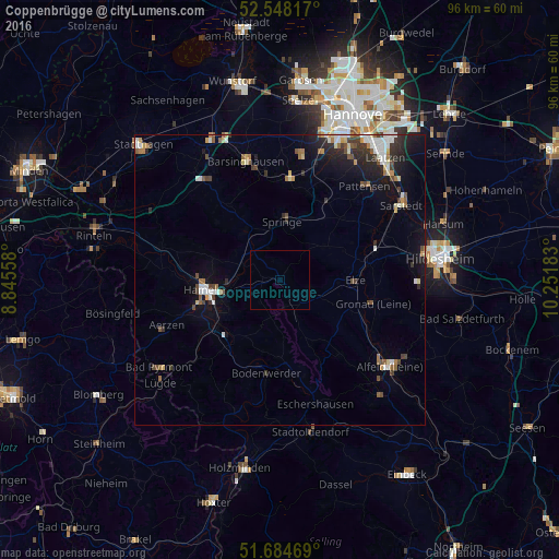
Analysis of Coppenbrügge night lights 2016
Square area 10x10 km:
 0%
0%90-99
0%80-89
0%70-79
0%60-69
0%50-59
0%40-49
0%30-39
0%20-29
0%10-19
0%0-9
100%Square area 50x50 km:
0.63%90-99
0.75%80-89
0.41%70-79
0.32%60-69
0.59%50-59
0.53%40-49
0.71%30-39
0.69%20-29
1.28%10-19
2.81%0-9
91.28%Clear (daylight) street map image can be seen on geolist.org.
Map coordinates:
52° 32' 53.4" North, 8° 50' 44.1" East
52° 7' 6.7" North, 9° 32' 55.3" East
51° 41' 4.9" North, 10° 15' 6.6" East
Some cities around Coppenbrügge sort by population:
• Hameln
13.2 km =8.2 mi,  262°
262°
• Springe
10 km =6.2 mi,  2°
2°
• Bad Münder am Deister
10.3 km =6.4 mi,  326°
326°
• Nordstemmen
16.7 km =10.4 mi,  73°
73°
• Salzhemmendorf
6.3 km =3.9 mi,  155°
155°
• Elze
12.8 km =8 mi,  87°
87°
• Bodenwerder
16.5 km =10.3 mi,  187°
187°
• Gronau
16 km =9.9 mi,  103°
103°
2939862 (p: 7,901)
Sources (retrieved 2019-11-25):
» Earth at Night: Flat Maps 2012, 2016