Bonndorf night lights from space
Night Light of Bonndorf (Baden-Württemberg) from space (Germany) Src. Average luminocity for 10x10km area is 0.4405% and for 50x50km: 2.2595%.
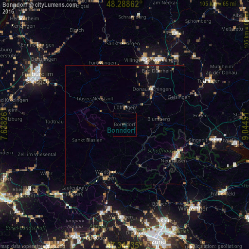
Analysis of Bonndorf night lights 2016
Square area 10x10 km:
 0%
0%90-99
0%80-89
0%70-79
0%60-69
0%50-59
0%40-49
0%30-39
1.19%20-29
0%10-19
0%0-9
98.81%Square area 50x50 km:
0.13%90-99
0.23%80-89
0.19%70-79
0.33%60-69
0.25%50-59
0.33%40-49
0.42%30-39
0.4%20-29
0.56%10-19
1.66%0-9
95.51%Clear (daylight) street map image can be seen on geolist.org.
Map coordinates:
48° 17' 19" North, 7° 38' 17.7" East
47° 49' 7.1" North, 8° 20' 29" East
47° 20' 39.7" North, 9° 2' 40.2" East
Some cities around Bonndorf sort by population:
• Titisee-Neustadt
16 km =9.9 mi,  315°
315°
• Blumberg
14.5 km =9 mi,  80°
80°
• Löffingen
7.3 km =4.5 mi,  1°
1°
• Staufen
11.9 km =7.4 mi,  234°
234°
• Bräunlingen
14.7 km =9.1 mi,  32°
32°
• Stühlingen
11.4 km =7.1 mi,  135°
135°
• Ühlingen-Birkendorf
11.5 km =7.1 mi,  189°
189°
• Lenzkirch
11.8 km =7.3 mi,  297°
297°
2946445 (p: 6,875)
Sources (retrieved 2019-11-25):
» Earth at Night: Flat Maps 2012, 2016